
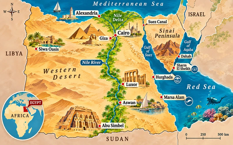
Quick Answer: Where is Egypt on the map?
Egypt is located in northeastern Africa, with the Sinai Peninsula extending into southwestern Asia. On a world map, Egypt lies between the Mediterranean Sea to the north and the Red Sea to the east. It borders Libya, Sudan, Israel, and the Gaza Strip. Its major destinations include Cairo, Giza, Alexandria, Luxor, Aswan, Hurghada, and Sharm El Sheikh.
Looking at Egypt on a map reveals something surprisingly useful: most of the country’s famous ancient monuments follow a relatively narrow geographical corridor along the Nile River, while its beach resorts, deserts, and Mediterranean cities occupy very different regions.
The Great Pyramids stand near Cairo in northern Egypt. The monumental temples of Luxor and Aswan are much farther south. The beaches of Hurghada and Marsa Alam stretch along the Red Sea coast, while Sharm El Sheikh occupies the southern Sinai Peninsula.
Understanding these relationships is essential when planning an Egypt itinerary for 2027.
Egypt covers approximately 1,002,000 square kilometers (about 387,000 square miles), but much of its population and historical settlement is concentrated around the Nile Valley, the Nile Delta, and several coastal and urban centers.
This Egypt on Map Guide explains where the country sits geographically, how its regions connect, where its major attractions are located, and which maps are most useful for planning a trip.
Where Is Egypt Located on the World Map?
Egypt occupies the northeastern corner of the African continent, close to the geographical meeting point of Africa, Asia, and Europe.
On a political world map, Egypt appears directly south of the Mediterranean Sea, northeast of Libya, north of Sudan, and west of the Red Sea and parts of the Middle East.
The country also includes the Sinai Peninsula, which is geographically part of Asia.
That makes Egypt a transcontinental country: its main territory lies in Africa, while Sinai lies in Asia.
Egypt on the Map of Africa
To identify Egypt on an Africa map, look at the continent’s northeastern corner.
Egypt lies immediately east of Libya and north of Sudan. Its northern coastline faces the Mediterranean Sea, and its northeastern territory reaches the Gulf of Aqaba.
Although Egypt is often associated with the Middle East, it is geographically classified as part of North Africa.
The country’s location explains why it has long been connected to African, Mediterranean, and West Asian civilizations.
Its principal geographical reference points are:
-
North: Mediterranean Sea and Nile Delta.
-
South: Sudan, Nubia, Lake Nasser, and the southern Nile Valley.
-
West: Libya and the Western Desert.
-
East: Red Sea and Eastern Desert.
-
Northeast: Sinai Peninsula, Israel, and the Gaza Strip.
Travelers examining a world map with Egypt highlighted will notice that the country lies relatively close to southeastern Europe and the Arabian Peninsula, although international travel routes depend on more than geographical distance.
Is Egypt in Africa or Asia?
Egypt is located in both Africa and Asia, but the vast majority of its territory lies in Africa.
The Sinai Peninsula is the country’s Asian territory.
The Suez Canal, running between the Mediterranean and Red Seas, provides a useful geographical reference for understanding the division between the African mainland and Sinai.
Cairo, Alexandria, Luxor, and Aswan are in Africa.
Sharm El Sheikh, Dahab, Nuweiba, Taba, and Mount Sinai are in Asia.
All are part of the same country.
This distinction becomes particularly interesting when travelers study Egypt’s geological, political, or continental maps.
Egypt on the Middle East Map
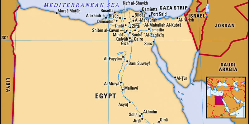
Egypt is commonly included in maps of the Middle East because of its political, cultural, linguistic, and historical connections with the region.
Arabic is Egypt’s official language, and the country maintains strong connections with the Arabian Peninsula and the wider Arab world.
On a Middle East map, Egypt lies southwest of Israel and Jordan, west of Saudi Arabia across the Red Sea, and southwest of countries such as Lebanon, Syria, and Turkey.
Egypt is also a central country in the broader Middle East and North Africa region, commonly abbreviated as MENA.
Important geographical distinction: Egypt does not share a land border with Jordan, Saudi Arabia, Turkey, Iran, or Lebanon. Those countries appear on wider regional maps, but they are not all immediate neighbors.
Egypt’s Geographical Coordinates
Egypt extends approximately between:
-
Latitude: 22°N and 32°N.
-
Longitude: 24°E and 37°E.
The country’s approximate central coordinates are 27°N, 30°E.
A latitude and longitude map of Egypt is particularly useful for identifying archaeological sites, desert routes, isolated settlements, and landmarks away from major roads.
GPS navigation uses geographical coordinates to identify precise positions. However, travelers should use verified location markers rather than approximate country coordinates when navigating to a particular attraction.
Map of Egypt and Surrounding Countries
A map of Egypt and neighboring countries shows how its position connects the Mediterranean, North Africa, the Nile Basin, and the Middle East.
Understanding the surrounding countries helps travelers distinguish actual borders from places that merely appear nearby on a small-scale map.
|
Country or territory |
Position relative to Egypt |
Geographical relationship |
|---|---|---|
|
Libya |
West |
Shares Egypt’s western land border |
|
Sudan |
South |
Shares Egypt’s southern land border |
|
Israel |
Northeast |
Shares a land border with Egypt’s Sinai Peninsula |
|
Gaza Strip |
Northeast |
Shares a short border with Egypt at Rafah |
|
Jordan |
Northeast, across the Gulf of Aqaba region |
No shared land border |
|
Saudi Arabia |
East, across the Red Sea and Gulf of Aqaba |
No shared land border |
|
Cyprus |
North, across the Mediterranean Sea |
No shared land border |
|
Ethiopia |
Farther south in northeastern Africa |
Connected to the wider Nile Basin, but not a direct neighbor |
Egypt and Libya on the Map
Libya lies west of Egypt.
The two countries share a long desert border, and western Egypt includes vast landscapes extending toward Libya.
Marsa Matrouh is located on Egypt’s northwestern Mediterranean coast. Farther inland, Siwa Oasis lies in the Western Desert relatively close to the Libyan frontier.
Although these locations appear near Libya on a regional map, international border arrangements should never be assumed from geographical proximity.
Egypt and Sudan on the Map
Sudan lies directly south of Egypt.
The Nile connects the two countries, flowing north from Sudan into Egypt.
Southern Egypt includes Aswan, Lake Nasser, Abu Simbel, and archaeological sites associated with ancient Nubia.
Lake Nasser extends across the international boundary, where the portion in Sudan is commonly called Lake Nubia.
Ancient Egyptian history cannot be fully understood without considering Sudan and the wider Nubian region.
Trade, cultural exchange, military activity, and political relationships connected Egypt with communities farther south for thousands of years.
Egypt, Israel, Jordan, and Saudi Arabia on the Map
The Sinai Peninsula occupies an important position between northeastern Africa and southwestern Asia.
Israel and the Gaza Strip lie along its northeastern boundaries.
Jordan is located across the northern Gulf of Aqaba region, while Saudi Arabia lies across the Gulf of Aqaba and Red Sea.
On a detailed map, travelers can identify Taba near the northern end of the Gulf of Aqaba, Nuweiba farther south, and Sharm El Sheikh near the southern tip of Sinai.
Do not confuse the short straight-line distances between some places with permission to cross international borders.
Visa requirements, border operations, security conditions, and transportation arrangements must be checked separately.
Egypt and Europe on the World Map
Egypt lies south of Europe across the Mediterranean Sea.
Countries such as Italy, Greece, Cyprus, Spain, and Turkey often appear in the same wider Mediterranean or Europe–Middle East map.
Cyprus is geographically much closer to Egypt than countries in northern Europe, but flying distances and available services vary by origin.
A map showing Egypt, Italy, Greece, Cyprus, and Turkey is particularly useful when organizing a multi-country Mediterranean itinerary.
Egypt also has historical connections with southern Europe through the Greek, Roman, and Byzantine periods.
Egypt, India, Russia, Morocco, and Other Countries
Egypt also appears on broader world maps alongside India, Russia, Morocco, Tunisia, Syria, Iran, and other countries.
These comparisons help explain Egypt’s international geographical position.
India lies farther east across Asia, Morocco and Tunisia lie west across North Africa, and Russia lies to the north across a much larger region.
A world political map is generally the most useful tool for comparing their positions.
For anyone searching where Egypt is located on a global map, the essential point is simple: Egypt occupies northeastern Africa, links geographically to Asia through Sinai, and faces the Mediterranean and Red Seas.
Map of Egypt With Cities: Where Are the Major Destinations?
A detailed map of Egypt with cities reveals that the country’s main destinations are distributed along several geographical corridors.
The largest concentration of historic cities follows the Nile. Important modern tourism centers are also found along the Mediterranean coast, Red Sea coast, and Sinai Peninsula.
Travelers can explore the relationships between these places through our guide to Egypt’s major cities.
Major Cities in Egypt and Their Locations
|
City or destination |
Location on Egypt’s map |
Main significance |
|---|---|---|
|
Cairo |
Northern Egypt, near the southern end of the Nile Delta |
National capital, museums, Islamic heritage |
|
Giza |
Immediately west of central Cairo |
Great Pyramids, Sphinx, Giza Plateau |
|
Alexandria |
Northwestern Mediterranean coast |
Ancient port city, Mediterranean history |
|
Port Said |
Northeastern Mediterranean coast |
Northern entrance to the Suez Canal |
|
Ismailia |
Along the Suez Canal |
Canal city and regional transport center |
|
Suez |
Northeastern Egypt, near the Gulf of Suez |
Southern entrance to the Suez Canal |
|
Mansoura |
Eastern Nile Delta |
Important Delta city |
|
Tanta |
Central Nile Delta |
Regional commercial and cultural center |
|
Damietta |
Northeastern Nile Delta |
Mediterranean port and river-delta city |
|
Fayoum |
Southwest of Greater Cairo |
Oasis landscape, lakes, archaeological sites |
|
Minya |
Middle Egypt, along the Nile |
Archaeological sites and regional history |
|
Asyut |
Central Nile Valley |
Major Upper Egyptian urban center |
|
Sohag |
Upper Egypt |
Ancient sites and Coptic heritage |
|
Qena |
Upper Egypt, north of Luxor |
Access to Dendera and surrounding areas |
|
Luxor |
Southern Nile Valley |
Karnak, Luxor Temple, royal tombs |
|
Aswan |
Southern Egypt |
Nubian heritage, Philae, Nile scenery |
|
Hurghada |
Western Red Sea coast |
Beach resorts, diving, marine excursions |
|
Marsa Alam |
Southern Red Sea coast |
Reefs, marine life, coastal tourism |
|
Sharm El Sheikh |
Southern Sinai Peninsula |
Red Sea resorts, snorkeling, diving |
|
Dahab |
Eastern Sinai coast |
Diving, beaches, mountain excursions |
|
Marsa Matrouh |
Northwestern Mediterranean coast |
Mediterranean beaches |
|
Abu Simbel |
Southern Egypt, near Lake Nasser |
Temples of Ramesses II and Nefertari |
These destinations are not all equally accessible from one another.
Cairo and Giza form part of one large metropolitan area. Luxor and Aswan follow the same river corridor but require substantial travel between them.
Sharm El Sheikh and Hurghada face the Red Sea from different sides of a complex coastal and maritime region.
A country-level map is therefore useful for choosing destinations, but a route map is essential for calculating transfers.
North Egypt, Middle Egypt, and South Egypt
Egypt is often described using northern, central, and southern geographical regions.
Northern Egypt includes the Mediterranean coastline, Nile Delta, Cairo, Alexandria, and Suez Canal area.
Middle Egypt commonly refers to the Nile Valley south of Greater Cairo and north of the Luxor region, including areas such as Beni Suef, Minya, and Asyut. Historical and administrative definitions can differ.
Southern Egypt includes much of Upper Egypt, particularly the region extending through Qena, Luxor, Aswan, and toward Sudan.
These regional descriptions are helpful, but they should not be confused with Egypt’s formal governorate boundaries.
Egypt’s 27 Governorates on a Political Map
Modern Egypt is administratively divided into 27 governorates.
A governorates map shows official administrative boundaries rather than tourist destinations alone.
The governorates are Cairo, Alexandria, Giza, Qalyubia, Beheira, Kafr El Sheikh, Gharbia, Monufia, Dakahlia, Damietta, Sharqia, Port Said, Ismailia, Suez, North Sinai, South Sinai, Red Sea, Matrouh, New Valley, Fayoum, Beni Suef, Minya, Asyut, Sohag, Qena, Luxor, and Aswan.
For travel planning, the distinction matters because a governorate can cover a very large area.
The Red Sea Governorate, for example, includes multiple coastal destinations separated by significant distances.
The New Valley Governorate covers extensive areas of the Western Desert.
A political map is useful for understanding administrative locations, but a tourist or road map is better for deciding how to travel.
Cairo Tourist Map: Understanding Cairo, Giza, and the Pyramids
Cairo is situated in northern Egypt near the southern edge of the Nile Delta.
It is also the central city of a much larger metropolitan region that extends into Giza and neighboring areas.
A map of Cairo and Giza should be one of the first planning tools for travelers visiting the capital.
Where Is Cairo on the Egypt Map?
Cairo lies on the Nile River in northern Egypt, considerably closer to the Mediterranean coast than to Egypt’s southern border.
Giza is located immediately west of Cairo, on the opposite side of the Nile from much of the city’s eastern urban area.
The Great Pyramids of Giza stand on the desert plateau at the western edge of Greater Cairo.
For first-time visitors, this means that Cairo’s urban attractions and the pyramids can belong to the same sightseeing itinerary, even though traffic and travel times need careful planning.
Explore the capital’s main highlights in our guide to things to do in Cairo.
Cairo and Giza Attractions Map
A useful Cairo tourist attractions map should distinguish several geographical zones.
|
Area |
What travelers will find |
Planning consideration |
|---|---|---|
|
Giza Plateau |
Great Pyramids, Sphinx, ancient tombs |
Allow significant time for the archaeological site |
|
Downtown Cairo |
Tahrir Square, Egyptian Museum, historic urban areas |
Best explored as a dedicated central-city area |
|
Islamic Cairo |
Historic mosques, Al-Muizz Street, Khan El Khalili |
Many attractions can be combined geographically |
|
Coptic Cairo |
Historic churches and religious heritage |
Plan around the Old Cairo district |
|
Cairo Citadel area |
Citadel, Mosque of Muhammad Ali |
A separate sightseeing cluster |
|
New Cairo |
Modern residential, business, and commercial districts |
Farther from many central historic attractions |
|
Saqqara and Memphis |
Ancient burial grounds and remains of Egypt’s early capital |
Located south of central Cairo |
|
Dahshur |
Bent Pyramid, Red Pyramid, surrounding necropolis |
Often combined with Saqqara on a dedicated excursion |
The table demonstrates why a detailed Cairo city map is more helpful than a simple Egypt map when planning individual sightseeing days.
Where Are the Pyramids of Giza on the Map?
The Great Pyramids are located on the Giza Plateau, west of the Nile.
The complex belongs to the ancient Memphis and its Necropolis World Heritage area, which includes pyramid fields extending south toward Dahshur.
The Giza Necropolis includes the pyramids of Khufu, Khafre, and Menkaure, along with smaller pyramids, tombs, temples, and the Great Sphinx.
Khufu’s pyramid is also known as the Great Pyramid or Pyramid of Cheops.
A detailed map of the Giza Plateau is useful for distinguishing between the pyramid complexes, entrance areas, viewpoints, and the Sphinx.
Do not assume that the three great pyramids are the only archaeological monuments in Giza.
The surrounding plateau preserves an extensive funerary landscape.
Where Are Saqqara, Memphis, and Dahshur?
Saqqara, Memphis, and Dahshur lie south of the main Giza Plateau.
They are closely connected geographically and historically.
Memphis served as an early capital of ancient Egypt. Saqqara was one of its major burial grounds and includes the famous Step Pyramid of Djoser.
Dahshur contains important royal pyramids, including those associated with Pharaoh Sneferu.
A map of ancient Egyptian pyramids makes their relationship especially clear.
Rather than appearing randomly across the desert, many major pyramid fields cluster along the western desert edge overlooking the Nile Valley.
For archaeological travelers, following this geographical arrangement is often more informative than visiting the monuments without understanding their historical setting.
Ancient Cairo, Islamic Cairo, and Old Cairo Maps
Travelers researching historic Cairo often encounter three related but distinct map labels.
Historic Cairo is a broad historical and heritage concept encompassing important areas of the city’s Islamic urban development and associated monuments.
Islamic Cairo generally refers to districts containing major Islamic architectural sites, including historic mosques, gates, streets, and marketplaces.
Old Cairo, particularly the Fustat and Coptic Cairo area, contains some of Egypt’s most important early Christian and Islamic historical sites.
These areas should not be treated as one small neighborhood.
A detailed street map helps visitors understand their individual locations and choose sensible walking routes.
Greater Cairo, New Cairo, and the New Administrative Capital
A modern map of Greater Cairo extends beyond the historical city center.
It includes large eastern and western urban districts such as New Cairo, Nasr City, Heliopolis, Maadi, Helwan, 6th of October City, and Sheikh Zayed.
The New Administrative Capital lies east of Cairo and is part of Egypt’s major modern urban development program.
Maps may use different labels, including New Administrative Capital or Egypt’s administrative capital.
Its geographical location should not be confused with central Cairo or with the historic sites clustered along the Nile.
Visitors using a Cairo street map to find hotels, shopping centers, offices, or residential districts should search the exact address and neighborhood.
For example, Mall of Arabia is associated with the 6th of October area rather than central historic Cairo.
When navigating, select the precise destination rather than relying on a broad city marker.
Alexandria Map: Egypt’s Mediterranean Coast and the Nile Delta
Alexandria is located on Egypt’s Mediterranean coastline, northwest of Cairo.
It is one of the country’s most important historical cities and was founded by Alexander the Great in 331 BCE.
On a map of Egypt and the Mediterranean Sea, Alexandria appears west of the Nile Delta’s main coastal branches.
Its position helped make it an important port, intellectual center, and connection between Egypt and the Mediterranean world.
Alexandria on the Map of Egypt
Alexandria lies along the Mediterranean coast, with Cairo to its southeast.
The city developed around its harbors and coastal urban areas, making the shoreline central to its geography.
A detailed Alexandria city map is particularly useful for locating:
-
Bibliotheca Alexandrina.
-
Citadel of Qaitbay.
-
The Corniche.
-
Montaza Palace and its gardens.
-
Catacombs of Kom El Shoqafa.
-
Pompey’s Pillar.
-
Historic districts and waterfront neighborhoods.
A map of Alexandria in ancient times looks very different from the modern street layout.
Historical maps often identify the ancient harbors, the location associated with the Pharos lighthouse, and the original Hellenistic urban plan.
For additional context, explore Alexandria’s historical attractions.
Alexandria in Cleopatra’s Time
During the Ptolemaic period, Alexandria became Egypt’s royal capital and an influential Mediterranean center.
Cleopatra VII ruled from this historical setting during the final decades of independent Ptolemaic Egypt.
A map of Cleopatra’s Egypt therefore usually emphasizes Alexandria, the Nile Delta, important Nile settlements, and the political relationships between Egypt and the Mediterranean world.
The famous ancient Lighthouse of Alexandria stood on Pharos Island, which became connected to the mainland.
The city also contained the renowned ancient Library of Alexandria, although its historical location and the development of related institutions are more complex than a single modern landmark marker might suggest.
A modern Alexandria map and an ancient Alexandria reconstruction serve different purposes.
The first helps travelers navigate the city today; the second helps explain what the city may have looked like in antiquity.
Nile Delta Map: Rosetta, Damietta, Mansoura, and Tanta
The Nile Delta occupies northern Egypt between Cairo and the Mediterranean Sea.
It is a broad, fertile region historically shaped by the Nile’s distributaries, irrigation networks, and agricultural settlement.
The two principal modern Nile branches are:
-
Rosetta Branch: The western branch, reaching the Mediterranean near Rosetta, also called Rashid.
-
Damietta Branch: The eastern branch, reaching the Mediterranean near Damietta.
Important Delta cities include Mansoura, Tanta, Zagazig, Damietta, and Kafr El Sheikh.
Rosetta is particularly important to the history of Egyptology because the Rosetta Stone was discovered in the region in 1799.
A Nile Delta map is useful for understanding why northern Egypt has a dense network of cities, canals, agricultural areas, and road connections.
Egypt North Coast Map: El Alamein and Marsa Matrouh
Egypt’s North Coast stretches westward along the Mediterranean, with prominent destinations including El Alamein and Marsa Matrouh.
A map of Egypt’s northern coastline helps distinguish the Alexandria area from the newer resort developments farther west.
El Alamein is also associated with important Second World War history.
Marsa Matrouh is known for its Mediterranean beaches and serves as a regional gateway toward western destinations, including Siwa Oasis.
Travelers should remember that the North Coast is not one compact resort.
Hotels and coastal developments can be separated by considerable distances.
The exact accommodation address is more useful than a general North Coast label.
Suez Canal Map: Port Said, Ismailia, and Suez
The Suez Canal is an artificial waterway connecting the Mediterranean Sea with the Red Sea.
It runs approximately north to south across the Isthmus of Suez.
On a map of the Suez Canal, three important cities are:
-
Port Said: Near the northern Mediterranean entrance.
-
Ismailia: In the central canal region.
-
Suez: Near the southern entrance and Gulf of Suez.
The canal is one of Egypt’s most geographically significant infrastructure features.
It connects two major seas and forms an important shipping route between Europe and Asian maritime trade networks.
Travelers should also distinguish the canal itself from nearby tourist destinations.
Ain Sokhna, for example, lies on the Gulf of Suez south of the canal area and is a coastal destination frequently associated with trips from Cairo.
Luxor and Aswan Map: The Ancient Heart of Upper Egypt
Luxor and Aswan are located in southern Egypt along the Nile River.
They are among the country’s most important archaeological destinations and form the core of many Nile cruise itineraries.
Looking at a map of Luxor and Aswan reveals how ancient temples, tombs, settlements, and agricultural landscapes developed around the Nile.
The river was Egypt’s principal geographical and historical connection between northern and southern regions.
Luxor on the Egypt Map
Luxor is situated in Upper Egypt, south of Qena and north of Aswan.
The modern city occupies the area of ancient Thebes, one of Egypt’s most influential religious and political centers.
Luxor’s archaeological geography is organized around the Nile’s east and west banks.
On the east bank are the city’s major temple complexes and much of the modern urban area.
On the west bank are the royal burial grounds and several major mortuary temples.
Understanding this arrangement makes a Luxor tourist map much easier to interpret.
Luxor East Bank Attractions
The East Bank contains two of Egypt’s most recognizable monuments:
-
Karnak Temple.
-
Luxor Temple.
Karnak developed into an extensive religious complex associated particularly with Amun and other deities.
Luxor Temple is located closer to the modern city center.
The two complexes are historically connected by the ancient processional route known as the Avenue of Sphinxes.
A Luxor city map should mark both temples and distinguish them from the West Bank archaeological areas.
Luxor West Bank Map
The West Bank contains some of ancient Egypt’s most important burial landscapes.
Major sites include:
-
The Valley of the Kings.
-
Valley of the Queens.
-
Temple of Hatshepsut.
-
Colossi of Memnon.
-
The Ramesseum.
-
Tombs of the Nobles.
On a map of ancient Thebes, these sites lie across the Nile from the principal eastern temple complexes.
The arrangement is historically meaningful.
The western landscape became closely associated with death, burial, and the afterlife.
The location of the Valley of the Kings within the desert hills also provided a setting for royal rock-cut tombs.
For visitors, the practical lesson is that East Bank and West Bank sightseeing should be planned as distinct geographical clusters.
Edfu and Kom Ombo on the Nile Map
Between Luxor and Aswan are two major temple destinations: Edfu and Kom Ombo.
Edfu is home to a major temple dedicated to Horus.
Kom Ombo contains a distinctive double temple associated with Sobek and Horus the Elder.
Both are important stops on many Upper Nile itineraries.
A map of the Nile River between Luxor and Aswan is particularly useful for identifying their positions and understanding the sequence of stops.
Southbound travelers generally encounter Edfu before Kom Ombo.
Northbound travelers encounter them in the reverse order.
Where Is Aswan on the Map?
Aswan lies farther south along the Nile, near the historical boundary between Egypt and Nubia.
Its geographical setting differs noticeably from Cairo and Luxor.
The river flows among granite outcrops, islands, and desert scenery.
Aswan is associated with the First Cataract region and has historically served as an important connection between Egypt and territories farther south.
Visitors exploring Aswan’s attractions can discover an area where archaeological history, Nubian culture, and Nile landscapes are closely connected.
Aswan City Map and Main Attractions
A detailed map of Aswan should show:
|
Attraction |
Map location or geographical relationship |
|---|---|
|
Elephantine Island |
Within the Nile, opposite central Aswan |
|
Nubian Museum |
On the east bank in Aswan |
|
Unfinished Obelisk |
In Aswan’s ancient granite quarry area |
|
Philae Temple |
On Agilkia Island, south of central Aswan |
|
Aswan High Dam |
South of the city |
|
Lake Nasser |
South of the High Dam |
|
Tombs of the Nobles |
West bank of the Nile |
|
Abu Simbel |
Much farther south, near Lake Nasser |
A city map can help organize the central attractions, but Abu Simbel requires a separate regional map because it is not part of the urban Aswan sightseeing area.
Aswan High Dam and Lake Nasser Map
The Aswan High Dam stands south of Aswan.
It created Lake Nasser, an enormous reservoir extending south through Egypt and across the border into Sudan.
On an Aswan dam map, the modern river valley and reservoir must be distinguished from the landscape before the dam was constructed.
This distinction is especially important when studying historic Nubian settlements and temples.
The creation of the reservoir threatened several major archaeological monuments with submersion.
International rescue campaigns led to the relocation of important monuments, including Abu Simbel and Philae.
Where Is Abu Simbel on the Map?
Abu Simbel lies in southern Egypt, southwest of Aswan, close to the western shore of Lake Nasser.
The temples were commissioned by Ramesses II and include the Great Temple and a smaller temple dedicated to Nefertari and Hathor.
The monuments were relocated to higher ground during the international effort to protect Nubian heritage from the waters of Lake Nasser.
The Abu Simbel temples are a major destination for visitors staying in Aswan, but the journey should not be confused with a short transfer across the city.
A regional map of southern Egypt clearly shows that Abu Simbel is a substantial distance beyond Aswan.
Many itineraries treat Abu Simbel as a dedicated excursion rather than combining it with numerous other archaeological sites on the same day.
Map of Nubia, Philae, and Southern Egypt
Nubia is a historical and geographical region extending through southern Egypt and northern Sudan.
Its cultural history includes Egyptian and Nubian kingdoms, trade networks, religious centers, and settlements along the Nile.
Maps of ancient Egypt and Nubia often highlight:
-
Elephantine Island.
-
First Cataract.
-
Philae.
-
Kalabsha.
-
Amada.
-
Wadi El Seboua.
-
Abu Simbel.
-
The Kingdom of Kush farther south.
Modern administrative borders should not be projected backward onto ancient cultures.
The historical region of Nubia extended across areas now divided between Egypt and Sudan.
This is one reason a modern political map and an ancient civilization map can tell significantly different stories about the same landscape.
Red Sea Map: Hurghada, Marsa Alam, and Sinai
Egypt’s Red Sea destinations are distributed along two major geographical areas: the African mainland’s eastern coastline and the shores of the Sinai Peninsula.
This distinction is essential when selecting beach resorts, comparing airports, or combining a coastal stay with archaeological sightseeing.
The Red Sea runs between northeastern Africa and the Arabian Peninsula.
Its northern end divides into the Gulf of Suez and Gulf of Aqaba, with the Sinai Peninsula between them.
Where Is Hurghada on the Egypt Map?
Hurghada lies on Egypt’s mainland Red Sea coast, southeast of Cairo and northeast of Luxor.
It is one of the country’s major beach and diving destinations.
The surrounding coastline includes several resort areas, each occupying a different geographical position.
A detailed Hurghada map should distinguish:
-
Central Hurghada.
-
El Gouna to the north.
-
Sahl Hasheesh to the south.
-
Makadi Bay farther south.
-
Soma Bay farther south along the coast.
-
Safaga beyond the main Hurghada resort corridor.
These areas are often collectively marketed as part of the Hurghada region, but they are not all within the same urban district.
Their locations matter when choosing accommodation or planning excursions.
Explore the destination further in our Hurghada travel guide.
El Gouna, Sahl Hasheesh, Makadi Bay, and Soma Bay Maps
El Gouna lies north of Hurghada and is known for its lagoon-based resort developments.
Sahl Hasheesh is situated south of Hurghada and includes coastal resorts and beachfront areas.
Makadi Bay lies farther south, while Soma Bay is located on a peninsula associated with the Safaga coastal region.
For travelers using a resort map, the most important details are the hotel’s precise location, beach access, surrounding services, and transport connections.
A map of a hotel complex may show pools, restaurants, and internal walking paths, but it does not explain how far the property is from the airport or nearby towns.
Large resort areas can also contain properties separated by significant distances.
Where Is Marsa Alam on the Map?
Marsa Alam lies on Egypt’s southern Red Sea coast, well south of Hurghada.
The wider tourism region contains resorts, coastal reefs, and marine attractions spread along a long stretch of shoreline.
A map of Marsa Alam should include the location of the individual resort, the relevant airport, nearby bays, and the coastal road.
Port Ghalib is an important resort and marina development near Marsa Alam International Airport.
Other names travelers may encounter include Abu Dabbab, El Quseir, and Berenice farther south.
Not all accommodation advertised under the broader Marsa Alam destination is close to Marsa Alam town.
For anyone researching the Marsa Alam region, the exact resort location is more useful than the town label alone.
Hurghada and Sharm El Sheikh on the Same Map
Hurghada and Sharm El Sheikh are both major Red Sea destinations, but they are located in different geographical areas.
Hurghada sits on the African mainland.
Sharm El Sheikh is situated at the southern end of the Sinai Peninsula, geographically in Asia.
A Red Sea map makes this relationship clear.
The two destinations may appear relatively close when measured across water, but this does not mean there is always a convenient direct transfer.
Ferry services, flights, and road connections vary. Travelers should verify available transport rather than assuming a short water crossing is operating.
Sharm El Sheikh Map: The Southern Sinai Peninsula
Sharm El Sheikh lies near the southern tip of Sinai, where the Gulf of Aqaba meets the northern Red Sea region.
The destination is known for marine tourism, beach resorts, and access to diving and snorkeling areas.
A Sharm El Sheikh city map can help visitors distinguish:
-
Naama Bay.
-
Sharks Bay.
-
Nabq Bay.
-
Sharm Old Market area.
-
Ras Mohammed National Park.
-
Nearby coastal and marina districts.
Ras Mohammed lies south of the main urban resort areas and is associated with important marine ecosystems.
Sharm El Sheikh’s location makes it particularly suitable for travelers who want a Red Sea resort stay with access to southern Sinai attractions.
Our Sharm El Sheikh destination guide provides additional information about the area.
Dahab, Nuweiba, Taba, and Mount Sinai
The eastern Sinai coastline stretches northward from the Sharm El Sheikh region toward Dahab, Nuweiba, and Taba.
Dahab is known for diving, a relaxed coastal atmosphere, and access to the mountainous Sinai interior.
Nuweiba occupies a position farther north along the Gulf of Aqaba.
Taba is located near Egypt’s northeastern frontier, close to the head of the Gulf of Aqaba.
A detailed Sinai map should also show the inland mountain region.
Mount Sinai and the Monastery of Saint Catherine lie within southern Sinai’s rugged interior, rather than directly on the coast.
Travelers should distinguish a beach itinerary from a mountain excursion because geography, road conditions, and required preparation differ.
Ain Sokhna and Ras Sudr on the Map
Ain Sokhna lies on the western coast of the Gulf of Suez, south of the city of Suez.
Its relative proximity to Greater Cairo makes it a common option for short coastal breaks.
Ras Sudr lies on the eastern side of the Gulf of Suez, within the Sinai Peninsula.
Although both destinations are associated with the same gulf, their geographical positions differ.
A detailed road map is essential when planning travel between them.
Egypt’s Western Desert, Oases, and Natural Landscapes on the Map
A physical map of Egypt reveals that the Nile Valley occupies only a small part of the country’s total land area.
Much of Egypt consists of deserts, plateaus, mountain systems, and low-lying basins.
The two principal desert regions are the Western Desert and the Eastern Desert.
Understanding these landscapes explains why Egypt’s cities, archaeological sites, agricultural areas, and major roads are distributed unevenly.
Western Desert Map: Siwa, Bahariya, Farafra, Dakhla, and Kharga
The Western Desert extends from the Nile Valley toward the Libyan border.
It contains vast areas of arid land as well as several important oases.
|
Oasis or region |
Position on the map |
Main characteristics |
|---|---|---|
|
Siwa Oasis |
Northwestern Western Desert |
Salt lakes, palm groves, Amazigh cultural heritage |
|
Bahariya Oasis |
West of the Nile Valley, southwest of Cairo |
Oasis settlements and access to desert excursions |
|
Farafra Oasis |
Southwest of Bahariya |
Desert landscapes and access to the White Desert |
|
Dakhla Oasis |
Southwestern Western Desert |
Historic settlements and agricultural areas |
|
Kharga Oasis |
Southern part of the Western Desert, west of the Nile |
Major oasis settlements and historical sites |
|
Fayoum |
Southwest of Cairo |
Lake Qarun, agricultural landscapes, nearby desert environments |
These destinations do not form a small group that can be explored in a single short excursion.
Some require long road journeys through sparsely populated areas.
A map showing only straight-line distances can significantly underestimate travel time.
Where Is Siwa Oasis on the Map?
Siwa Oasis is situated in Egypt’s northwestern Western Desert, relatively close to the Libyan border.
It is geographically separate from the main Nile Valley tourist circuit.
Siwa is associated with the Oracle Temple of Amun, traditional oasis settlements, palm cultivation, and distinctive desert landscapes.
The Siwa Oasis guide provides a closer look at this unusual region.
Travelers should not assume that Siwa is a convenient day trip from Cairo merely because it appears within the northern part of Egypt.
It usually requires a dedicated excursion with appropriate transport arrangements.
Bahariya Oasis and the White Desert
Bahariya Oasis lies west of the Nile Valley and serves as an important access point for parts of Egypt’s Western Desert.
The nearby Black Desert and the White Desert are known for contrasting geological landscapes.
The White Desert is particularly associated with distinctive pale rock formations shaped by natural erosion.
A map of Bahariya Oasis and the White Desert should distinguish inhabited oasis settlements from remote desert terrain.
For travelers interested in the region, our Bahariya Oasis guide explains its setting and attractions.
Remote desert exploration requires careful route planning, suitable vehicles, awareness of protected-area requirements, and experienced local arrangements where necessary.
Ordinary city navigation apps should not be treated as sufficient preparation for off-road desert travel.
Fayoum on the Egypt Map
Fayoum is located southwest of Greater Cairo, within a depression connected to the Nile Valley through an ancient and modern water-management system.
The region includes agricultural landscapes, archaeological sites, and important natural environments.
Lake Qarun is one of Fayoum’s best-known geographical features.
Wadi El Rayan and Wadi Al Hitan are also associated with the wider Fayoum desert region.
A map of ancient Fayoum can look different from a current map because water levels, agricultural areas, settlements, and lake environments have changed over time.
The historical term Lake Moeris appears in discussions of the region’s ancient geography.
Eastern Desert and Red Sea Mountains
The Eastern Desert occupies the region between the Nile Valley and the Red Sea.
Unlike the broad Western Desert, much of the Eastern Desert is characterized by rugged mountains, wadis, and mineral-rich geological formations.
Historically, routes through this region connected Nile settlements with Red Sea ports and quarrying areas.
Ancient Egyptians obtained materials from desert quarries and used routes linking the Nile Valley with eastern trade networks.
A geological or topographic map is particularly helpful for understanding this region because a simple political map reveals little about its mountainous terrain.
Mount Catherine, Mount Sinai, and Egyptian Elevation Maps
Egypt is not entirely flat.
A physical or elevation map shows high mountains in southern Sinai, the Red Sea Hills, desert plateaus, and low-lying depressions.
Mount Catherine, also called Jabal Katrinah, is generally identified as Egypt’s highest mountain.
Mount Sinai is another important peak in the southern Sinai mountain region.
These mountains illustrate why the Sinai Peninsula has a very different landscape from the Nile Delta.
Travelers interested in trekking should use detailed terrain maps and current local guidance rather than relying on a basic tourist map.
Ancient Egypt Map: Upper Egypt, Lower Egypt, and the Nile River
One of the most important questions in Egyptian historical geography is why Upper Egypt lies in the south while Lower Egypt lies in the north.
The answer is the direction of the Nile.
The Nile flows northward through Egypt toward the Mediterranean Sea.
Ancient Egyptian geographical terminology followed the river’s upstream and downstream positions.
Map of Upper and Lower Egypt Explained
Upper Egypt refers to the upstream Nile Valley in southern Egypt. Lower Egypt refers to the downstream Nile Delta region in northern Egypt.
The names do not describe which region appears at the top or bottom of a modern north-oriented map.
|
Feature |
Upper Egypt |
Lower Egypt |
|---|---|---|
|
Relative location |
South |
North |
|
Relationship to the Nile |
Upstream |
Downstream |
|
Main landscape |
Narrow Nile Valley |
Broad Nile Delta |
|
Historical examples |
Thebes, Abydos, Elephantine |
Memphis region, Delta settlements |
|
Traditional royal symbol |
White Crown |
Red Crown |
|
Main geographical significance |
Southern river corridor |
Northern fertile Delta and Mediterranean access |
The political unification of Upper and Lower Egypt became a central theme of ancient Egyptian kingship.
The Double Crown symbolized royal authority over both regions.
Understanding this geographical division helps explain Egyptian royal imagery, historical maps, and the positioning of early political centers.
Ancient Egypt and the Nile River Map
The Nile was the central geographical feature of ancient Egyptian civilization.
It provided water, fertile agricultural land, and a major transportation corridor through an otherwise largely arid environment.
Ancient settlements developed along the river and its branches.
The river also connected important cities and religious centers, including Memphis, Abydos, Thebes, and Elephantine.
A detailed ancient Egypt Nile map should show the river’s northward direction and the difference between the narrow valley and the Delta.
Our guide explaining why the Nile River was important to ancient Egypt explores this relationship in greater depth.
Ancient Egyptian Cities on the Map
Ancient Egyptian cities were not distributed in the same way as modern urban centers.
Some settlements grew around political capitals, temple complexes, military positions, or trade routes.
Others were associated with religious institutions and burial grounds.
Important historical geographical names include:
-
Memphis: Major early political and administrative center near the entrance to the Delta.
-
Thebes: Modern Luxor, important during the Middle and New Kingdoms.
-
Abydos: Major religious and funerary center north of Luxor.
-
Akhetaten: The city established under Akhenaten at the site now known as Amarna.
-
Elephantine: Island settlement near Aswan and the First Cataract.
-
Edfu: Important religious center associated with Horus.
-
Heliopolis: Major ancient religious center in the northeastern Cairo region.
-
Alexandria: Major capital and Mediterranean center during the Ptolemaic period.
The locations of these cities reveal how political power and religious importance shifted across Egypt over time.
A historical map becomes much more useful when it is labeled with both ancient and modern place names.
Ancient Egypt Kingdom Maps: Old, Middle, and New Kingdoms
Maps of the Old Kingdom, Middle Kingdom, and New Kingdom show different political landscapes.
During the Old Kingdom, Memphis and the surrounding pyramid fields played central roles in royal administration and monumental construction.
The Middle Kingdom saw major political activity associated with Thebes and other administrative centers.
During the New Kingdom, Thebes became particularly important, while Egyptian influence expanded into areas of Nubia and the eastern Mediterranean region.
The boundaries shown on Egyptian empire maps are historical reconstructions rather than modern national borders.
Historians distinguish direct administration, military influence, tributary relationships, and periods of temporary control.
A map presenting the largest possible territorial extent of an Egyptian kingdom should therefore be read with its historical date and supporting interpretation in mind.
For additional background, explore our guide to ancient Egypt and its civilization.
Map of Ancient Egypt, Kush, and Nubia
Kush was an important ancient kingdom located primarily in the region of modern Sudan.
Egypt and Kush maintained complex relationships involving trade, conflict, political influence, and cultural exchange.
At certain times, Egyptian rulers controlled parts of Nubia.
During the Twenty-Fifth Dynasty, rulers of Kush also governed Egypt.
A map of Egypt and Kush should therefore show historical relationships rather than treating modern Egypt–Sudan boundaries as permanent ancient divisions.
Nubia’s position along the Nile made it an important corridor for goods, people, religious practices, and political power.
Ancient Egypt, Mesopotamia, and the Middle East Map
Egypt and Mesopotamia were distinct centers of ancient civilization.
Mesopotamia developed around the Tigris and Euphrates rivers, principally in the area of modern Iraq and surrounding territories.
Egypt developed along the Nile.
Regional maps help explain the relationships between the Nile Valley, the Levant, Anatolia, Mesopotamia, and Persia.
Trade and diplomatic relationships connected these regions across long periods.
Ancient trade-route maps may also show connections through Sinai, the Mediterranean, the Red Sea, and desert corridors.
These relationships changed substantially between the Bronze Age, Persian period, Hellenistic period, and Roman period.
A single map of the ancient Middle East cannot accurately represent every historical era.
Egypt During Biblical Times
Maps of Egypt during biblical times often show Egypt alongside Canaan, Sinai, the Levant, and Mesopotamia.
Readers may encounter labels such as the Land of Goshen, the River of Egypt, the Euphrates River, or routes associated with biblical narratives.
These maps require careful interpretation.
The identification of specific ancient place names or proposed travel routes is sometimes debated.
For example, the expression “River of Egypt” may be interpreted differently depending on the biblical text, historical period, and scholarly tradition.
It should not automatically be equated with the modern Nile River.
Similarly, maps showing territories extending toward the Euphrates may refer to historical influence, military campaigns, or textual interpretations rather than stable national boundaries.
Travelers interested in biblical geography should distinguish archaeological evidence, historical scholarship, and religious tradition.
Cleopatra’s Egypt and Roman Egypt Maps
A map of Egypt during Cleopatra VII’s reign emphasizes the Ptolemaic kingdom and its Mediterranean connections.
Alexandria was the royal capital.
The Nile Valley remained central to the country’s economy and settlement.
After the death of Cleopatra VII in 30 BCE, Egypt became a Roman province.
Roman Egypt maps may emphasize administrative regions, military routes, settlements, and connections to the wider Roman Empire.
Historical maps from these different periods should never be combined without identifying the century they represent.
Antique Maps of Egypt vs Modern Geographical Maps
An antique map of Egypt may contain older place names, unfamiliar boundaries, and geographical inaccuracies.
Some historical maps prioritize cities, trade routes, monuments, or religious sites rather than precise measurement.
Others reflect the mapping technologies and political knowledge of their creators.
Antique maps can be valuable historical documents, but they are not suitable for present-day navigation.
A modern GPS road map, archaeological site plan, and eighteenth-century map of Egypt each answer a different question.
Physical Geography of Egypt: Rivers, Mountains, Deserts, and Lakes
A geographical map of Egypt shows more than country boundaries.
It reveals the natural conditions that shaped Egyptian settlement, agriculture, transportation, and ancient history.
The most important physical features are the Nile, the Delta, the Western Desert, the Eastern Desert, the Sinai mountains, the Red Sea coastline, and the Mediterranean coast.
Nile River Map: Where Does the Nile Flow?
The Nile enters Egypt from Sudan and flows north toward the Mediterranean Sea.
Its course passes through southern Egypt, the Nile Valley, Greater Cairo, and the Delta.
At the Delta, the river divides into the Rosetta and Damietta branches.
A simple Egypt river map should therefore highlight the Nile as the country’s principal river system.
The river’s geographical importance is difficult to overstate.
Most historical Egyptian population centers depended on access to the Nile or connected water systems.
However, Egypt’s wider geography also includes groundwater, oases, irrigation networks, reservoirs, and desert drainage systems.
Lakes of Egypt Map
Egypt has several significant lakes and reservoirs.
|
Lake or water body |
Location |
Why it matters |
|---|---|---|
|
Lake Nasser |
Southern Egypt |
Major reservoir created by the Aswan High Dam |
|
Lake Qarun |
Fayoum |
Significant lake in the Fayoum Depression |
|
Lake Manzala |
Northeastern Nile Delta |
Important coastal lagoon |
|
Lake Burullus |
Northern Nile Delta |
Coastal wetland and lagoon |
|
Lake Edku |
Northwestern Delta |
Coastal lagoon |
|
Bitter Lakes |
Suez Canal region |
Part of the canal’s waterway system |
|
Wadi El Rayan lakes |
Fayoum region |
Lakes within a desert protected-area landscape |
A lake map of Egypt is particularly useful for understanding why the country’s northern coastline and southern Nile Valley have different aquatic environments.
The lakes also support diverse ecological systems, although water conditions and conservation challenges vary.
Egypt Elevation and Topographic Maps
A topographic map represents variations in land elevation.
Egypt’s most important topographic features include:
-
The Nile Valley, a relatively low-lying corridor.
-
The Nile Delta, a broad, low-elevation coastal plain.
-
The Western Desert’s plateaus and depressions.
-
The Red Sea Hills in the Eastern Desert.
-
Southern Sinai’s high mountains.
-
The Qattara Depression in northwestern Egypt.
A relief or contour map helps explain why some desert routes are geographically challenging even when two locations appear close together.
Egypt Geological and Natural Resources Maps
Egypt has extensive geological diversity.
Geological maps show rock formations, faults, sedimentary basins, and other features of the country’s geological history.
Natural resource maps may identify areas associated with petroleum, natural gas, mineral deposits, quarrying, and groundwater.
Ancient Egyptian quarrying also reflects this geological diversity.
Granite from Aswan, for example, was used in important architectural and sculptural projects.
Other stone resources came from locations across the Nile Valley and deserts.
Geological and hydrogeological maps are particularly useful for academic research and engineering studies.
They should not be confused with ordinary tourist maps.
Egypt Climate, Rainfall, and Vegetation Maps
A climate map of Egypt generally shows arid conditions across most of the country, with Mediterranean influences in parts of the north.
Rainfall is limited in much of the interior.
A vegetation map reveals the contrast between the Nile’s agricultural corridor and the surrounding deserts.
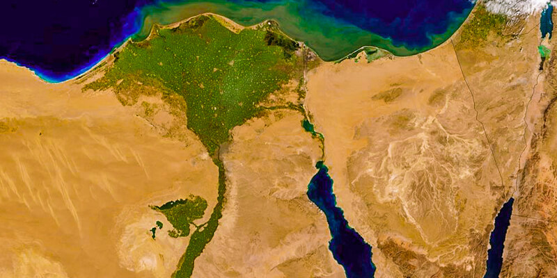
Satellite views often make this contrast especially clear.
The green Nile Valley and Delta stand out against much of the surrounding desert landscape.
Live weather maps, rainfall maps, and seasonal climate maps provide different kinds of information.
A rainfall map shows precipitation patterns, while a current weather map may display temperature, wind, cloud cover, or storms.
For travel planning, current forecasts should always take precedence over general historical averages when weather-sensitive activities are involved.
Types of Egypt Maps: Which One Should Travelers Use?
Not every Egypt map is designed for the same purpose.
A world map is useful for locating the country. A tourist map identifies attractions. A road map supports transportation planning, while a historical map explains ancient civilizations.
Choosing the right map can prevent misunderstandings about distances, access, and geographical relationships.
Comparing the Most Useful Egypt Map Types
|
Map type |
Best use |
What to look for |
|---|---|---|
|
Egypt world map |
Understanding international location |
Africa, Asia, surrounding seas and countries |
|
Political map |
Understanding borders and governorates |
Countries, cities, administrative boundaries |
|
Physical map |
Studying natural geography |
Nile, deserts, mountains, lakes |
|
Detailed tourist map |
Planning attractions |
Archaeological sites, resorts, museums |
|
Road map |
Planning transfers |
Highways, road connections, route alternatives |
|
Interactive map |
Exploring individual destinations |
Searchable locations and zoom functions |
|
Satellite map |
Understanding real terrain |
Urban areas, coastlines, desert features |
|
3D terrain map |
Studying landscapes and elevation |
Mountains, valleys, relief |
|
Historical map |
Understanding ancient Egypt |
Ancient cities, kingdoms, trade routes |
|
Printable outline map |
Education and geographical study |
Country shape and clearly defined boundaries |
|
Geological map |
Researching physical formations |
Rock units, geological structures |
|
Weather map |
Checking conditions |
Temperature, wind, rain, current forecasts |
Interactive Map of Egypt
An interactive Egypt map is especially useful for travelers because it allows users to move between different scales.
At the country level, visitors can identify Cairo, Luxor, Aswan, Alexandria, and Red Sea destinations.
Zooming in reveals individual roads, monuments, hotels, airports, and neighborhoods.
Useful interactive mapping features include searchable place names, route planning, satellite imagery, location sharing, and offline access.
However, interactive maps are not always equally reliable in remote desert regions or newly developed areas.
Locations should be verified through official attraction information and current local navigation guidance.
Printable Map of Egypt
A printable map is useful for families, teachers, students, and travelers who want a physical reference.
Several formats serve different purposes.
A labeled map of Egypt should include major cities, neighboring countries, the Nile, deserts, and principal seas.
A blank Egypt map or empty outline map allows students to label geographical features independently.
A black-and-white Egypt map is useful for worksheets and economical printing.
A high-resolution Egypt map is better for large printed educational materials.
An SVG Egypt map is a scalable vector file, suitable for resizing without the normal pixelation of raster images.
A PDF tourist map is practical for offline reference when a document is correctly formatted for printing or mobile viewing.
Check the map’s publication date, scale, licensing terms, and intended purpose before downloading or reproducing it.
A file being available online does not automatically mean it can be reused commercially.
Where to Find an Official Egypt Map
For authoritative geographical reference, travelers can consult map publications from the Egyptian General Authority for Survey.
Egypt’s official tourism resources also provide destination information and geographical planning material.
Specialized archaeological maps are available through heritage authorities and established academic institutions.
When selecting a map, prioritize clarity, current place names, readable labels, appropriate geographic scale, and reliable provenance.
An official administrative map may be accurate for governorate boundaries but less convenient for locating hotels and tourist attractions.
Egypt Maps in Arabic and Other Languages
International travelers may encounter different language versions of Egyptian place names.
Egypt is called Misr in Arabic, written مصر.
The country’s official Arabic name is جمهورية مصر العربية, meaning Arab Republic of Egypt.
Some maps label Cairo as Al-Qahira, while the English name remains Cairo.
Other common spelling variations include:
-
Cairo, Kairo, and Le Caire.
-
Giza, Gizeh, and Gize.
-
Asyut, Assiut, and Asyout.
-
Fayoum, Fayum, and Faiyum.
-
Marsa Matrouh and Mersa Matruh.
-
Sharm El Sheikh and Sharm El Sheik.
-
Rosetta and Rashid.
Travelers searching in other languages may encounter terms such as mapa de Egipto, mapa do Egito, Egypt karta, peta Mesir, or egyiptom térkép.
These are language or spelling variations related to maps of Egypt.
When using a navigation application, alternative spellings can be helpful if a destination does not appear under its most familiar English name.
How to Use an Egypt Tourist Map to Plan Your 2027 Trip
An Egypt tourist map is most valuable when it helps travelers choose a realistic route.
The country contains several distinct tourism regions, and trying to cover them all without considering travel logistics can lead to unnecessary transfers.
A useful itinerary should group attractions geographically rather than simply arranging famous landmarks in an arbitrary sequence.
The Five Main Egypt Travel Regions
For trip planning, Egypt can be divided into five broad visitor regions.
Greater Cairo and Giza: Pyramids, museums, historic neighborhoods, Saqqara, and nearby archaeological areas.
Alexandria and the Mediterranean: Coastal history, Alexandria, El Alamein, Marsa Matrouh, and selected Delta destinations.
Luxor and Aswan: Major Upper Egyptian temples, royal tombs, Nile cruises, Nubian heritage, and Abu Simbel.
Red Sea and Sinai: Beach resorts, diving, snorkeling, mountain excursions, and marine environments.
Western Desert and Oases: Siwa, Bahariya, the White Desert, Farafra, Dakhla, Kharga, and desert landscapes.
These regions can be combined, but each additional region creates a transportation requirement.
Egypt Map With Major Attractions
For a first-time visitor, the essential geographical relationships are:
|
Attraction |
Closest major base |
General geographical position |
|---|---|---|
|
Great Pyramids and Sphinx |
Cairo or Giza |
Western edge of Greater Cairo |
|
Grand Egyptian Museum |
Giza |
Near the Giza Plateau |
|
Saqqara |
Cairo or Giza |
South of Greater Cairo |
|
Bibliotheca Alexandrina |
Alexandria |
Mediterranean coast |
|
Karnak Temple |
Luxor |
East bank of the Nile |
|
Valley of the Kings |
Luxor |
West bank of the Nile |
|
Edfu Temple |
Edfu / Nile cruise route |
Between Luxor and Aswan |
|
Kom Ombo Temple |
Kom Ombo / Nile cruise route |
North of Aswan |
|
Philae Temple |
Aswan |
South of the city, on Agilkia Island |
|
Abu Simbel |
Aswan or Abu Simbel |
Southern Egypt, near Lake Nasser |
|
Ras Mohammed National Park |
Sharm El Sheikh |
Southern Sinai |
|
White Desert |
Bahariya/Farafra region |
Western Desert |
Before planning visits to archaeological sites, check current opening arrangements, ticket categories, and transportation availability.
Attractions in the same general region can still require separate excursions.
What Is the Most Efficient Route Through Egypt?
For a classic first-time trip focused on ancient Egyptian history, the most practical geographical progression is often:
Cairo and Giza → Luxor → Aswan → optional Abu Simbel.
This follows the principal north-to-south archaeological corridor.
A Red Sea stay can then be added when the transport connections fit the itinerary.
Travelers who want to avoid unnecessary backtracking should examine their international arrival and departure airports before choosing the final order.
Sometimes a route that looks slightly less direct on a country map is more efficient because of available transport schedules.
Egypt Travel Distances: Why a Map Can Be Misleading
A map shows geographical relationships, but it does not always reveal actual journey times.
|
Journey |
Geographical relationship |
Sensible transport approach |
|---|---|---|
|
Cairo to Giza Pyramids |
Same wider metropolitan region |
Private transfer or suitable road transport |
|
Cairo to Alexandria |
Northern Egypt to Mediterranean coast |
Road or rail |
|
Cairo to Luxor |
Northern Egypt to Upper Egypt |
Domestic flight or rail |
|
Luxor to Aswan |
Southbound along the Nile |
Road, rail, or Nile cruise |
|
Aswan to Abu Simbel |
Farther south toward Lake Nasser |
Dedicated road excursion or available flight |
|
Cairo to Hurghada |
Inland capital to Red Sea coast |
Road or available flight |
|
Cairo to Sharm El Sheikh |
Mainland capital to southern Sinai |
Road or available flight |
|
Cairo to Siwa |
Capital to remote northwestern oasis |
Long-distance road journey |
|
Luxor to Hurghada |
Nile Valley to Red Sea coast |
Road transfer |
|
Hurghada to Sharm El Sheikh |
Opposite sides of a Red Sea/Gulf region |
Check currently operating transport services |
Travel time depends on road routes, traffic, transportation schedules, stops, and local conditions.
A straight line between two cities should not be used as a reliable estimate of the journey.
Egypt Itinerary Map for 3, 5, 7, 10, or 14 Days
The ideal geographical coverage depends on the length of the vacation.
|
Trip duration |
Suggested geographical focus |
Recommended approach |
|---|---|---|
|
3 days |
Cairo and Giza |
Concentrate on one metropolitan region |
|
5 days |
Cairo/Giza plus Luxor |
Focus on major archaeological sites |
|
7 days |
Cairo, Luxor, and Aswan |
Combine northern and southern highlights |
|
10 days |
Cairo, Luxor, Aswan, and optional Red Sea |
Balanced historical and leisure itinerary |
|
14 days |
Cairo, Alexandria, Upper Egypt, and Red Sea |
Broader coverage with more flexibility |
These are suggested planning frameworks, not fixed tour schedules.
A three-day visit is generally too short to explore Cairo, Luxor, Aswan, Abu Simbel, and the Red Sea comfortably.
Travelers who want detailed day-by-day sequencing can use our 10-day Egypt itinerary as a starting point.
Cairo and Giza: A Geographically Efficient Short Trip
A short visit can concentrate on the main Cairo region.
On the first day, travelers might focus on the Giza Plateau and a nearby museum, depending on opening arrangements and personal interests.
A second day can concentrate on central and historic Cairo.
A third day can be reserved for Saqqara, Memphis, and Dahshur, or for additional Cairo attractions.
This approach reduces the need for domestic flights and keeps the trip within a relatively coherent geographical area.
Cairo, Luxor, and Aswan: A Classic Seven-Day Route
Seven days allow travelers to explore multiple parts of Egypt while maintaining a clear geographical sequence.
A possible structure is:
-
Two or three days in Cairo and Giza.
-
Two days in Luxor.
-
Two days in Aswan and its surroundings.
The precise allocation depends on arrival and departure flights, preferred activities, and the importance of Abu Simbel.
If Abu Simbel is a priority, its travel requirements should be considered before finalizing the Aswan schedule.
Ten Days: Add a Nile Cruise or the Red Sea
Ten days provide more flexibility for combining major archaeological destinations with another experience.
Travelers can follow Cairo and Giza with Luxor and Aswan, using a Nile cruise where suitable.
A traditional Egypt Nile cruise connects several important Upper Egyptian destinations along the river.
Alternatively, visitors may prefer a shorter archaeological route followed by a beach stay.
Choosing between these options should depend on interests and transport logistics, not simply the desire to include more cities.
Fourteen Days: Explore Different Egyptian Landscapes
A two-week itinerary can introduce more geographical variety.
One option combines Cairo, Alexandria, Luxor, Aswan, and a Red Sea destination.
Another emphasizes archaeological sites and adds Abu Simbel, Dendera, Abydos, or other historically important locations.
Travelers particularly interested in desert environments may prefer to exchange some coastal time for a properly organized oasis excursion.
There is no need to visit every region.
A well-planned trip with fewer destinations can provide a more rewarding experience than an itinerary dominated by transfers.
Egypt Weather Map: Which Regions Are Best in Different Seasons?
Egypt’s climate varies by region.
The Mediterranean coast has a different seasonal pattern from the southern Nile Valley, while the Red Sea coast and Sinai mountains have their own conditions.
A climate map provides useful background, but visitors should also check current forecasts for their exact destinations.
Egypt Weather by Region
|
Region |
General climate characteristics |
Main travel consideration |
|---|---|---|
|
Cairo and Giza |
Hot summers, generally milder winters |
Outdoor archaeology can be more comfortable in cooler months |
|
Alexandria and North Coast |
Mediterranean influence |
Cooler, wetter winter conditions than many inland areas |
|
Luxor and Aswan |
Very hot summers, generally pleasant winter daytime conditions |
Heat is a major factor for outdoor sightseeing |
|
Hurghada and Marsa Alam |
Arid Red Sea coastal climate |
Wind, water conditions, and seasonal temperatures matter |
|
Sharm El Sheikh and Dahab |
Arid coastal climate |
Conditions vary between beaches and inland mountain areas |
|
Sinai mountains |
Higher-elevation mountain climate |
Nights and winter conditions can be much colder |
|
Western Desert |
Arid climate with substantial temperature variations |
Daytime heat, nighttime cooling, and remote travel preparation |
For monthly planning, our Egypt weather by month guide explains the seasonal differences.
Best Time to Visit Egypt Based on Its Geography
For many travelers focused on Cairo, Luxor, Aswan, and outdoor archaeological sites, October through April often offers more comfortable sightseeing conditions than the peak summer months.
Winter can be especially appealing in southern Egypt, although nights may be cooler than expected.
The Mediterranean coast is more strongly associated with summer beach travel.
Red Sea resorts attract visitors throughout the year, but water temperatures, wind, and individual preferences should influence the choice of season.
Our guide to the best time to visit Egypt provides additional regional guidance.
Important Weather Considerations for 2027
Travelers visiting in 2027 should remember that historical climate averages are not forecasts for a specific travel date.
Heatwaves, strong winds, occasional rainfall, reduced visibility, and other weather events can affect individual journeys.
Desert excursions and boat trips are especially sensitive to conditions.
Check current forecasts shortly before departure and again before activities where weather affects safety or access.
How to Navigate Egypt Safely and Efficiently
A map is a useful planning tool, but safe navigation requires more than identifying a destination.
Transport availability, local regulations, road conditions, and appropriate travel arrangements all matter.
Airports on the Egypt Map
Egypt has several airports serving different regions.
Important international gateways include Cairo International Airport, Sphinx International Airport, Borg El Arab International Airport, Hurghada International Airport, Sharm El Sheikh International Airport, Luxor International Airport, Aswan International Airport, and Marsa Alam International Airport.
Not every airport serves the same international or domestic routes.
Some have seasonal services, while others are primarily useful for specific travel regions.
Before purchasing flights, confirm which airport is closest to your intended destination and whether suitable connections operate on your travel dates.
Road Map of Egypt
Egypt’s major road connections link Cairo with Alexandria, the Nile Valley, the Suez Canal area, and Red Sea destinations.
Road maps can identify major highways and alternative routes.
However, not every line visible on a map represents a route suitable for independent tourist driving.
Remote deserts, sensitive border regions, and certain road corridors can involve additional practical or regulatory considerations.
Use current navigation guidance and verify appropriate local arrangements before traveling outside established tourist routes.
GPS Maps, Offline Navigation, and Street Maps
Digital mapping services are useful for city navigation.
Google Maps, Apple Maps, OpenStreetMap-based applications, and other navigation systems can help identify roads and nearby facilities.
Some travelers may encounter older GPS map products, including iGO-based navigation maps.
Whichever system is used, check that the underlying map data is current.
Before traveling:
-
Save the exact hotel address.
-
Download offline maps where supported.
-
Identify airport and railway-station locations.
-
Save the main archaeological site entrances, not only their general names.
-
Keep essential transport information available without internet access.
-
Confirm desert and remote-area routes with a qualified local operator where appropriate.
A street map of Cairo, for example, may include several similarly named districts or roads.
Using an exact address or a verified location marker can prevent navigation errors.
Egypt’s Borders and Travel Advisories
Maps showing Egypt and surrounding countries should not be interpreted as border-crossing guides.
International crossing arrangements can change independently of geography.
For travel in 2027, consult the relevant Egyptian authorities and the current official travel advice issued by your home country.
This is particularly important for border regions and travel involving neighboring countries.
Do not rely on outdated online descriptions of crossing procedures.
Common Mistakes When Reading an Egypt Map
Understanding a few common mistakes makes planning much easier.
Mistake 1: Assuming everything near the Nile is close together.
The Nile connects Cairo, Luxor, Aswan, and many other destinations, but the distances between cities remain substantial.
Mistake 2: Confusing Hurghada with Sharm El Sheikh.
Both are Red Sea destinations, but they are located on different sides of the northern Red Sea region.
Mistake 3: Assuming Abu Simbel is inside Aswan city.
Abu Simbel is much farther south and normally requires a separate excursion.
Mistake 4: Confusing Upper Egypt with northern Egypt.
Upper Egypt refers to the upstream southern Nile Valley.
Mistake 5: Using a historical map for current directions.
Ancient cities, borders, river channels, and place names may differ significantly from their modern equivalents.
Mistake 6: Assuming a road is open because it appears on a digital map.
Maps may not reflect every restriction, temporary closure, or operational change.
Mistake 7: Planning every attraction from one hotel.
A hotel in central Cairo, for example, is not automatically convenient for every destination in Greater Cairo.
Mistake 8: Relying only on straight-line distances.
Actual travel depends on available routes, not simply the distance between two map markers.
Mistake 9: Treating all Red Sea resort names as interchangeable.
El Gouna, Makadi Bay, Soma Bay, Marsa Alam, and Sharm El Sheikh have different geographical positions and transport requirements.
Mistake 10: Ignoring the scale of the country.
Egypt’s archaeological attractions are concentrated along major corridors, but its desert and coastal regions extend across enormous areas.
For broader practical advice, consult our Egypt travel tips.
Frequently Asked Questions About Egypt on the Map
1. Where is Egypt located on the world map?
Egypt is located in northeastern Africa, with the Sinai Peninsula extending into southwestern Asia. It lies south of the Mediterranean Sea, west of the Red Sea, east of Libya, and north of Sudan. Cairo is the national capital, while major tourist destinations include Giza, Alexandria, Luxor, Aswan, Hurghada, and Sharm El Sheikh.
2. Is Egypt part of Africa or the Middle East?
Egypt is geographically part of northeastern Africa, with a smaller territory in Asia through the Sinai Peninsula. It is also commonly classified as part of the Middle East because of its historical, cultural, political, and linguistic connections with the region. The two classifications describe different aspects of Egypt’s identity and location.
3. Where is Cairo located in Egypt?
Cairo is located in northern Egypt along the Nile, near the southern end of the Nile Delta. Giza lies immediately to the west, forming part of the wider metropolitan area. The Great Pyramids are situated on the desert plateau at the western edge of Greater Cairo.
4. Where is the Red Sea on a map of Egypt?
The Red Sea lies to the east of mainland Egypt. Its northern end includes the Gulf of Suez and the Gulf of Aqaba, which border different sides of the Sinai Peninsula. Hurghada and Marsa Alam are on Egypt’s mainland Red Sea coast, while Sharm El Sheikh and Dahab are in Sinai.
5. Can I visit Cairo, Luxor, and Aswan on one trip?
Yes. Cairo, Luxor, and Aswan are commonly combined in Egyptian travel itineraries because they lie along the country’s main archaeological tourism corridor. However, the distances are considerable, and suitable transportation must be arranged. Around seven to ten days can provide a useful framework, depending on the chosen attractions and travel pace.
6. What is the difference between a political and physical map of Egypt?
A political map emphasizes national borders, governorates, cities, and administrative divisions. A physical map focuses on geographical features such as the Nile River, deserts, mountains, valleys, and lakes. A tourist map adds major attractions, museums, resorts, airports, and roads that help visitors plan their journeys.
7. Can I download a free printable map of Egypt?
Printable Egypt maps are available from mapping, educational, and geographical resources. However, their permitted use varies. Look for a clearly labeled map with an appropriate scale, source, publication date, and license. A free-to-download map is not necessarily free for commercial publication or redistribution.
8. What is the best map for visiting the Egyptian pyramids?
A detailed Giza Plateau archaeological map is most useful for exploring the Great Pyramids, Sphinx, tombs, and entrances. A broader Cairo–Giza map helps plan hotel transfers. If visiting Saqqara and Dahshur as well, use a regional map showing the pyramid fields south of Giza.
9. Is Alexandria close to Cairo?
Alexandria is northwest of Cairo on the Mediterranean coast. The cities are connected by road and rail and can be combined within one itinerary. However, the journey requires a substantial transfer, so travelers should consider transport schedules, traffic, and sightseeing time rather than treating Alexandria as part of Greater Cairo.
10. Where is the closest beach destination to Cairo?
Ain Sokhna, on the Gulf of Suez, is one of the more geographically convenient coastal destinations from Greater Cairo. Other beach regions, including Hurghada and the Mediterranean coast, require different travel arrangements. The best choice depends on the departure location, available transport, accommodation preferences, and desired activities.
11. Why do ancient Egypt maps look different from modern Egypt maps?
Ancient Egypt maps show historical settlements, kingdoms, routes, and landscapes from specific periods. Modern maps show contemporary borders, roads, cities, infrastructure, and geographical features. Changes in settlement patterns, administrative boundaries, waterways, and the construction of major infrastructure such as the Aswan High Dam also influence the differences.
12. What should an Egypt tourist map include for a 2027 vacation?
A practical Egypt tourist map should identify major cities, airports, archaeological destinations, the Nile River, Red Sea resort regions, and relevant road or rail connections. Travelers should also use detailed local maps for Cairo, Giza, Luxor, Aswan, and their chosen resorts. Current transportation schedules and access rules need separate verification.
Final Thoughts: Understanding Egypt on the Map Before You Travel
Egypt’s geography explains much of what makes the country historically and culturally distinctive.
The Nile connects major ancient cities and archaeological sites from the Delta toward Nubia. The Mediterranean coast reveals Egypt’s connections with the ancient Mediterranean world. The Red Sea and Sinai offer entirely different landscapes, while the Western Desert contains remote oases and remarkable geological formations.
For travelers planning a visit in 2027, the most useful approach is to begin with a map of Egypt showing its major regions, then move to detailed city and attraction maps.
Choose destinations that work together geographically, allow enough time for transportation, and confirm current access arrangements before departure.
If you want help connecting Cairo, Giza, Luxor, Aswan, and other destinations into one practical route, Egypt Time Travel can help organize tailor-made Egypt trips around your interests, travel dates, and preferred pace.
A good Egypt on Map Guide should do more than show where the country is located. It should help you understand the landscape, appreciate its history, and make better decisions about what to visit.
