
Quick Answer: Where was ancient Egypt located on the map?
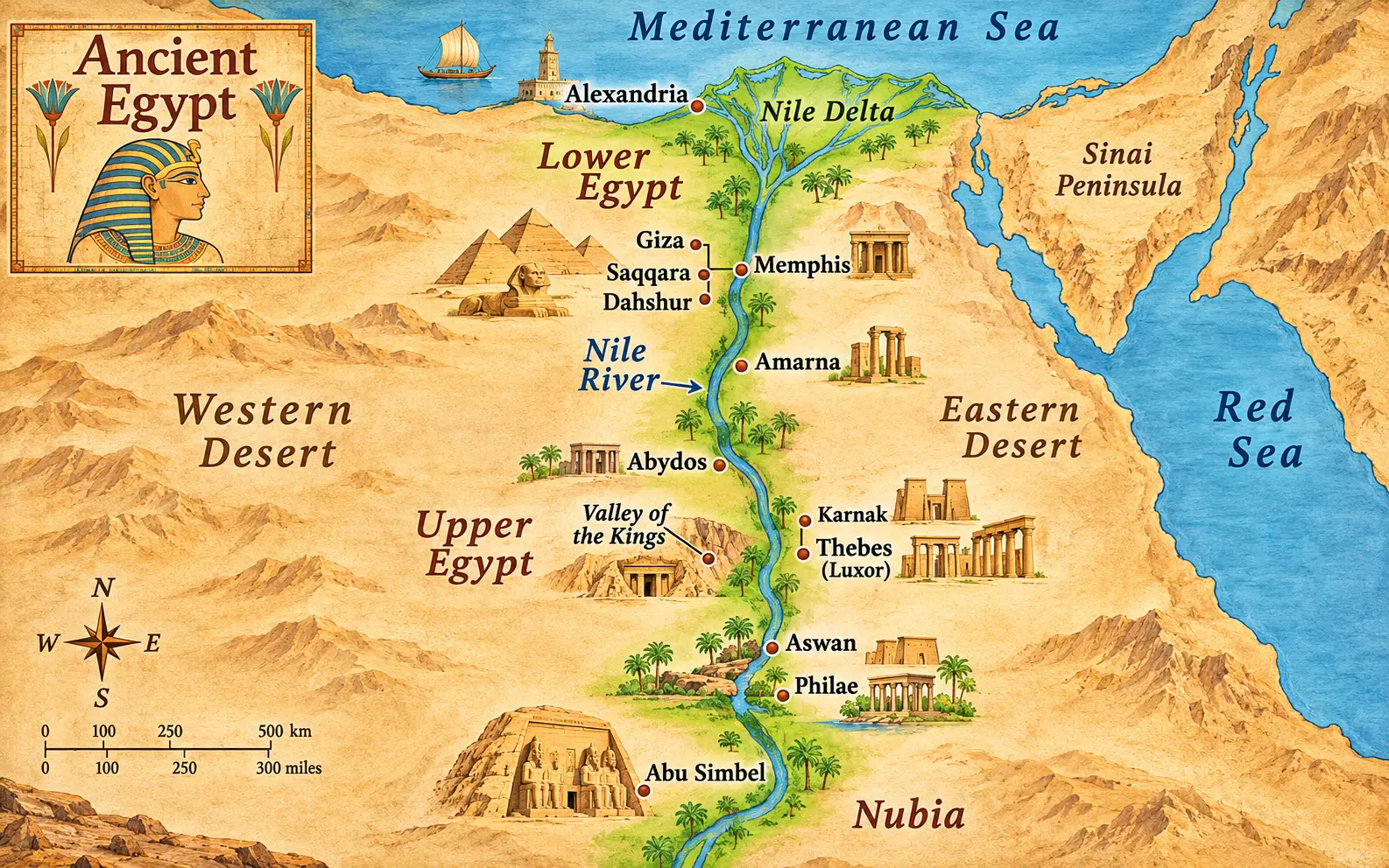
Ancient Egypt was located in northeastern Africa, primarily along the Nile River and its fertile delta in present-day Egypt. Its historic heartland extended from the Mediterranean coast in the north to the First Cataract near Aswan in the south. A map of ancient Egypt shows two principal regions: Lower Egypt in the north and Upper Egypt in the south, connected by the north-flowing Nile.
The most important feature on any ancient Egypt map is not a pyramid, temple, or city. It is the Nile River.
Almost every major center of ancient Egyptian civilization developed alongside this river or within reach of its waterways. Memphis rose near the southern entrance to the Nile Delta. The pyramids were constructed on the desert plateau west of the river. Thebes became a powerful religious and political center farther south, while Aswan formed an important gateway to Nubia.
Understanding these relationships changes how you see Egypt.
A map of Egypt in ancient times reveals why certain cities became capitals, why pharaohs built monuments in particular locations, how agricultural communities survived in an arid environment, and why the Nile connected regions that might otherwise have remained isolated.
For travelers planning to visit Egypt in 2027, this geographical knowledge also provides a practical advantage. It helps explain which ancient sites can be explored together, which destinations require additional travel, and why a journey between Cairo, Luxor, and Aswan follows the geographical foundations of Egyptian history.
Where Was Ancient Egypt Located on the World Map?
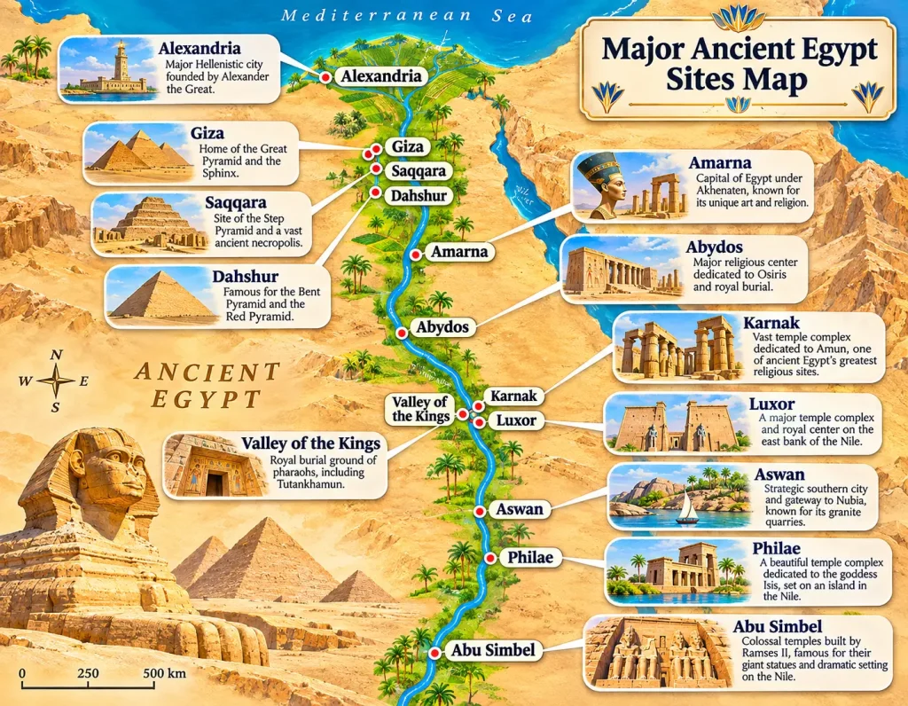
Ancient Egypt was situated in northeastern Africa, at the meeting point of the African continent, the Mediterranean world, and routes leading toward southwestern Asia.
Its central geographical feature was the Nile Valley, a long corridor of fertile land surrounded by deserts.
On a modern world map, ancient Egypt’s principal settlements correspond to areas within today’s Arab Republic of Egypt. However, the territories controlled by Egyptian rulers changed substantially throughout the civilization’s history.
At different times, Egyptian influence extended into Nubia, parts of the Levant, and other neighboring regions.
Ancient Egypt’s geographical position
|
Direction |
Geographical feature |
Historical importance |
|---|---|---|
|
North |
Mediterranean Sea |
Maritime connections, coastal settlements, and later Alexandria |
|
South |
Nubia and the Upper Nile |
Trade, gold resources, diplomatic relations, and military campaigns |
|
East |
Eastern Desert and Red Sea |
Mineral resources, quarrying, and access to Red Sea routes |
|
West |
Western Desert and Sahara |
Natural barriers, oases, and desert trade routes |
|
Northeast |
Sinai Peninsula |
Access to mineral resources and overland routes toward the Levant |
|
Central corridor |
Nile River and Nile Valley |
Agriculture, population centers, transportation, and political integration |
The Nile Valley was therefore both Egypt’s agricultural foundation and its principal transportation corridor.
Was ancient Egypt in Africa or Asia?
Ancient Egypt was an African civilization.
Its main agricultural settlements, important cities, royal cemeteries, and religious centers developed in northeastern Africa.
The Sinai Peninsula, which lies geographically in Asia, was connected to Egyptian history through trade, mining, military activity, and religious traditions.
Consequently, ancient Egypt is best understood as an African civilization with extensive connections to neighboring African and Asian regions.
Where is ancient Egypt located on a modern map?
The principal archaeological regions correspond to recognizable modern destinations:
-
Cairo and Giza: Ancient Memphis, the Giza pyramids, Saqqara, and Dahshur.
-
Middle Egypt: Beni Hasan, Hermopolis, Amarna, and other historical settlements.
-
Luxor: Ancient Thebes, Karnak, Luxor Temple, and royal necropolises.
-
Aswan: Elephantine Island, ancient quarries, Philae, and the southern Nile corridor.
-
Abu Simbel: Monumental temples associated with Ramesses II in historical Nubia.
-
Alexandria: A major Mediterranean city founded during the late fourth century BCE.
For a broader understanding of the country’s present-day geography, explore this guide to Egypt on the map.
An important distinction is that modern Egypt and ancient Egypt are not identical political or geographical concepts. Present-day national borders should not be projected backward onto every historical period.
How to Read an Ancient Egypt Map With Labels
A useful ancient Egypt labeled map should explain geography before introducing individual monuments.
The clearest maps distinguish rivers, cultivated land, deserts, historical regions, settlements, religious centers, and burial grounds.
They should also identify the historical period being represented.
A map labeled “Ancient Egypt” without a date may combine places separated by more than two thousand years of history.
Essential features every detailed map of ancient Egypt should show
|
Map label |
Where to locate it |
What it explains |
|---|---|---|
|
Nile River |
Through Egypt’s main north-south corridor |
Foundation of settlement and transport |
|
Nile Delta |
Northern Egypt beside the Mediterranean |
Fertile region containing numerous historical settlements |
|
Lower Egypt |
Northern Nile region, especially the Delta |
One of Egypt’s two traditional political regions |
|
Upper Egypt |
Southern Nile Valley |
The upstream region of the Egyptian kingdom |
|
Mediterranean Sea |
Across the northern coast |
Maritime geography and connections |
|
Red Sea |
East of mainland Egypt |
Access to coastal and maritime trade routes |
|
Western Desert |
West of the Nile Valley |
Oasis settlements and desert routes |
|
Eastern Desert |
Between the Nile and Red Sea |
Quarries, minerals, and trade routes |
|
Sinai Peninsula |
Northeast of mainland Egypt |
Routes toward Asia and mineral resources |
|
Memphis |
South of modern Cairo |
Early political and religious center |
|
Giza |
West of the Nile near Cairo |
Old Kingdom royal pyramids |
|
Saqqara |
South of Giza |
Major royal and elite cemetery |
|
Amarna |
Middle Egypt |
Capital established by Akhenaten |
|
Abydos |
Upper Egypt, north of Luxor |
Early royal burials and religious importance |
|
Thebes |
Modern Luxor |
Major royal and religious center |
|
Aswan |
Southern Egypt |
First Cataract region and gateway to Nubia |
|
Nubia |
South of Egypt’s traditional heartland |
Neighboring cultures, kingdoms, and important interactions |
|
Abu Simbel |
South of Aswan |
New Kingdom temples of Ramesses II |
Not every ancient Egypt map needs all these labels.
A basic classroom map may need only the Nile, Delta, Upper Egypt, Lower Egypt, major cities, seas, and deserts.
An archaeological map should include individual sites, chronological information, and historical place names.
A travel map benefits more from modern city names, archaeological locations, transportation corridors, and realistic regional groupings.
Ancient names versus modern names
One of the most common sources of confusion is the difference between historical and modern place names.
For example:
-
Thebes corresponds to the Luxor region.
-
Ancient Ineb-Hedj, later Memphis, was located south of modern Cairo.
-
Akhetaten corresponds to the archaeological site of Amarna.
-
Ancient Swenett, known to the Greeks as Syene, corresponds to the Aswan area.
-
Waset was the ancient Egyptian name of Thebes.
-
Per-Wadjet, associated with Buto, was a significant Delta religious center.
Some ancient settlements have disappeared beneath later occupation. Others survive primarily as archaeological remains near modern towns.
Practical map-reading rule: Always check whether a place name identifies an ancient settlement, a modern city, an archaeological site, or an entire geographical region.
These categories are related but are not interchangeable.
Upper Egypt and Lower Egypt: Why Is Southern Egypt Called Upper?
Upper Egypt is in the south, while Lower Egypt is in the north.
This terminology follows the Nile River’s direction of flow rather than the arrangement of countries on a conventional north-up map.
The Nile flows downstream from the south toward the Mediterranean Sea in the north.
Southern Egypt is upstream and therefore called Upper Egypt. Northern Egypt is downstream and therefore called Lower Egypt.
This distinction was central to Egyptian geography, politics, religion, and royal identity.
Upper Egypt: The southern Nile Valley
Upper Egypt traditionally extended northward from the First Cataract near Aswan through the Nile Valley toward the region south of Memphis.
It contained important early political and religious centers, including:
-
Nekhen, or Hierakonpolis.
-
Abydos.
-
Thebes.
-
Elephantine.
-
Edfu.
-
Gebelein.
The geography of Upper Egypt was relatively narrow.
Agricultural settlements occupied strips of fertile land along the Nile, with desert plateaus rising beyond the cultivated fields.
In some areas, the valley widened considerably. In others, cultivated land was constrained by the surrounding terrain.
Upper Egypt played a major role in the emergence of Egyptian kingship during the late Predynastic and Early Dynastic periods.
Later, Thebes became a particularly influential center of religion and royal authority.
Lower Egypt: The northern Nile Delta
Lower Egypt included the northern Nile Valley and the broad Delta region, where the river divided into branches before entering the Mediterranean.
The Delta supported agricultural settlements, trading centers, religious institutions, and political capitals.
Important historical locations included:
-
Buto.
-
Sais.
-
Tanis.
-
Avaris.
-
Pi-Ramesses.
-
Bubastis.
-
Heliopolis.
The Delta’s geography was more complex than that of the southern valley.
Its waterways, wetlands, cultivated areas, and settlements changed as river channels shifted over time.
An accurate ancient Nile Delta map should therefore identify its historical period rather than assume that today’s two principal river branches represent the entire ancient river system.
Upper Egypt versus Lower Egypt
|
Feature |
Upper Egypt |
Lower Egypt |
|---|---|---|
|
Position |
South |
North |
|
Relation to Nile |
Upstream |
Downstream |
|
Main landscape |
Long, relatively narrow river valley |
Broad Delta and northern river plain |
|
Traditional crown |
White Crown, Hedjet |
Red Crown, Deshret |
|
Associated plant |
Lotus |
Papyrus |
|
Major ancient centers |
Abydos, Thebes, Nekhen |
Buto, Sais, Tanis, Avaris |
|
Important modern destinations |
Luxor, Aswan, Sohag, Qena |
Cairo region and Nile Delta |
The Two Lands and the double crown
Ancient Egyptian rulers described their kingdom through the concept of the Two Lands.
The White Crown represented Upper Egypt, while the Red Crown represented Lower Egypt.
Together, they formed the Double Crown, symbolizing royal authority over both regions.
This political symbolism was especially important because Egypt’s history included periods of unification, fragmentation, and reunification.
The joining of Upper and Lower Egypt was not merely a change on a map. It became one of the defining ideas of Egyptian kingship.
Ancient Egypt Map of the Nile River: The Geography That Built a Civilization
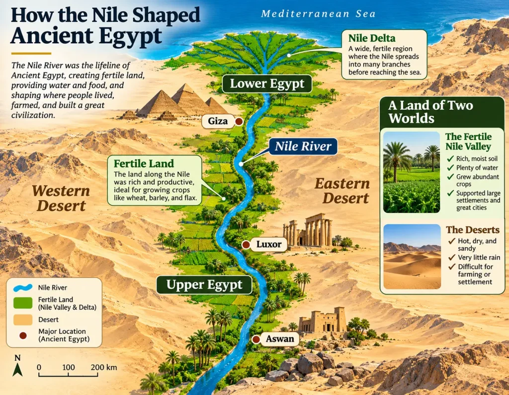
The Nile River was the geographical foundation of ancient Egyptian civilization.
Its course connected agricultural settlements, regional religious centers, administrative cities, quarrying areas, and royal capitals.
Without the Nile, the distribution of ancient Egypt’s major population centers would have been dramatically different.
Where did the Nile flow in ancient Egypt?
The Nile entered Egypt from the south, flowed northward through the valley, and eventually divided into channels across the Delta before reaching the Mediterranean Sea.
The river belonged to a much larger northeastern African drainage system extending far beyond Egypt.
Within the ancient Egyptian heartland, its principal geographical sequence was:
Southern Nile and Nubia → Aswan → Upper Egypt → Middle Egypt → Memphis region → Nile Delta → Mediterranean Sea.
On a map of ancient Egypt and the Nile, most major settlements appear close to the river.
This was not accidental.
The Nile supplied water, created cultivable floodplain soils, supported boat transportation, and connected different communities.
Explore the historical relationship between the river and Egyptian civilization in why the Nile River was important to ancient Egypt.
The annual Nile flood
Before modern flood regulation, the Nile experienced a seasonal inundation that was essential to ancient agriculture.
Floodwaters spread across portions of the valley and Delta, depositing sediment and replenishing soil moisture.
After the waters receded, farmers cultivated crops in the fertile floodplain.
The agricultural cycle was strongly connected to the river’s seasonal behavior.
Ancient Egyptians recognized three broad agricultural seasons:
-
Akhet: The inundation season.
-
Peret: The growing season, when land emerged from the waters.
-
Shemu: The harvesting season.
The actual timing and extent of inundation varied.
Insufficient flooding could reduce agricultural production. Exceptionally high flooding could damage settlements and infrastructure.
The Nile was therefore both a source of prosperity and an environmental force that required continuous management.
Black Land and Red Land
Ancient Egyptians commonly distinguished between fertile cultivated land and the surrounding desert.
The fertile valley was associated with Kemet, often translated as “Black Land.”
The desert was associated with Deshret, meaning “Red Land.”
These terms described contrasting landscapes that existed side by side.
The division is particularly evident on a physical map of ancient Egypt.
A relatively narrow agricultural corridor appears beside large desert regions.
The contrast helps explain why settlements, temples, and cemeteries frequently occupy different parts of the same landscape.
Why were many tombs built in the desert?
Royal and elite tombs were often constructed in desert areas beyond the cultivated floodplain.
Several considerations influenced their locations, including religious traditions, geology, available land, and the desire to protect burial structures from agricultural activity and seasonal flooding.
In the Memphis region, major pyramid complexes occupy the desert plateau to the west of the Nile.
At Thebes, important royal tombs were excavated into the western desert hills.
The geography of these cemeteries illustrates a broader relationship between living settlements, cultivation, religious monuments, and the landscape of burial.
It would nevertheless be inaccurate to assume that every Egyptian tomb was located west of the Nile or that all western land had only funerary uses.
How did the Nile function as an ancient highway?
River transportation was one of ancient Egypt’s most important geographical advantages.
Boats carried people, food, administrative supplies, building materials, and luxury goods.
The river’s northward current helped vessels traveling downstream.
North winds, which commonly blow toward the south, could assist sailing vessels moving upstream.
This combination made the Nile a practical transportation corridor in both directions, although conditions varied.
The movement of large stone blocks for royal monuments also depended partly on waterways and associated transport infrastructure.
For readers researching the wider river system, the length of the Nile River provides additional geographical context.
The Nile cataracts and the southern frontier
A cataract is a rocky stretch of a river characterized by rapids, exposed rocks, or navigational obstacles.
The Nile cataracts were historically significant because they complicated river travel and influenced the movement of goods, people, and military forces.
The First Cataract, near Aswan, was particularly important in Egyptian geography.
It helped define the southern edge of Egypt’s traditional core region and marked a transition toward Nubia.
However, Egypt’s actual political control did not always end there.
During certain periods, Egyptian rulers controlled territories well beyond the First Cataract.
Important distinction: The First Cataract was a major geographical landmark, not a permanent international boundary.
Map of Ancient Egypt With Labels: Major Cities and Archaeological Sites
A detailed map of ancient Egypt should identify not only where places were located but also when and why they mattered.
The following reference connects important historical locations with the nearest recognizable modern geographical areas.
Ancient Egypt locations from north to south
|
Ancient location |
Modern geographical reference |
Historical importance |
|---|---|---|
|
Alexandria |
Alexandria |
Ptolemaic and Roman capital, Mediterranean intellectual center |
|
Canopus |
Abu Qir area, Alexandria |
Ancient coastal religious and settlement area |
|
Sais |
Sa el-Hagar, Nile Delta |
Important Late Period political center |
|
Tanis |
San el-Hagar, eastern Delta |
Major city during the Third Intermediate Period |
|
Avaris |
Tell el-Dab’a, eastern Delta |
Hyksos-period capital |
|
Pi-Ramesses |
Qantir area, eastern Delta |
Important Ramesside royal residence |
|
Heliopolis |
Greater Cairo area |
Major center of solar religious traditions |
|
Memphis |
Mit Rahina, south of Cairo |
Early administrative and religious center |
|
Giza |
Giza Plateau |
Fourth Dynasty pyramid complexes |
|
Saqqara |
South of Giza |
Ancient necropolis including Djoser’s Step Pyramid |
|
Dahshur |
South of Saqqara |
Major pyramid-building area |
|
Faiyum and Shedet |
Fayoum region |
Agricultural, religious, and settlement center |
|
Beni Hasan |
Minya Governorate |
Middle Kingdom rock-cut tombs |
|
Hermopolis |
El-Ashmunein |
Important religious and intellectual center |
|
Akhetaten |
Amarna, Minya Governorate |
Akhenaten’s royal capital |
|
Abydos |
Sohag Governorate |
Early royal cemetery and Osiris cult center |
|
Dendera |
Qena Governorate |
Major religious complex associated with Hathor |
|
Thebes |
Luxor |
Religious and political center |
|
Karnak |
Eastern Luxor |
Extensive temple complex associated especially with Amun |
|
Edfu |
Edfu, Upper Egypt |
Major temple center associated with Horus |
|
Kom Ombo |
North of Aswan |
Temple complex associated with Sobek and Horus the Elder |
|
Elephantine |
Aswan |
Island settlement, trading center, and southern gateway |
|
Philae |
Aswan area |
Major Isis sanctuary |
|
Abu Simbel |
South of Aswan |
Rock-cut temples of Ramesses II and Nefertari |
This table identifies locations rather than presenting a single historical snapshot.
For example, the pyramids at Giza belong to the Old Kingdom, while Alexandria became a major city much later, following its foundation in 331 BCE.
Displaying both on one educational map is useful, provided the reader understands their different historical contexts.
Which ancient Egyptian sites are most important on a map?
For first-time readers, six geographical groups provide an especially useful foundation.
Memphis and its cemeteries: Explain the early Egyptian state and the great pyramid-building landscape.
Thebes and its necropolis: Explain New Kingdom religious institutions and royal burial traditions.
Amarna: Illustrates an exceptional period of political and religious change under Akhenaten.
Abydos: Connects early Egyptian kingship with later religious traditions.
Aswan and Nubia: Explain Egypt’s southern frontier, mineral resources, and relations with neighboring civilizations.
Alexandria: Represents the transformation of Egypt under Greek and Roman rule.
These locations are not equally important in every historical period.
Their combined value is that they demonstrate how Egypt’s political, cultural, and religious geography changed over time.
Ancient Egypt Timeline: How the Map Changed Across the Kingdoms
Ancient Egyptian civilization developed over thousands of years.
During this time, capitals shifted, religious centers gained or lost influence, frontier regions changed hands, and new cities appeared.
A historical map should therefore be associated with a particular period.
The dates below are approximate, particularly for the earlier periods. Egyptological chronological systems differ slightly between institutions and publications.
|
Historical period |
Approximate dates |
Main geographical developments |
|---|---|---|
|
Predynastic Period |
Before c. 3100 BCE |
Regional communities and emerging political centers in the Nile Valley and Delta |
|
Early Dynastic Period |
c. 3100–2650 BCE |
Consolidation of kingship and the importance of Memphis and Abydos |
|
Old Kingdom |
c. 2650–2150 BCE |
Strong Memphite administration and extensive pyramid construction |
|
First Intermediate Period |
c. 2150–2030 BCE |
Political fragmentation and competing regional centers |
|
Middle Kingdom |
c. 2030–1640 BCE |
Reunification, major Nile Valley development, and increased activity in Nubia |
|
Second Intermediate Period |
c. 1640–1550 BCE |
Rival authorities in northern and southern Egypt |
|
New Kingdom |
c. 1550–1070 BCE |
Major Theban religious influence, southern expansion, and important Delta residences |
|
Third Intermediate Period |
c. 1070–712 BCE |
Political division and important Delta centers |
|
Late Period |
c. 712–332 BCE |
Changing dynasties, foreign interventions, and major political centers |
|
Ptolemaic Period |
332–30 BCE |
Alexandria becomes the leading royal and administrative center |
|
Roman Period |
From 30 BCE |
Egypt becomes a province of the Roman Empire |
Early Egypt: Before the kingdom was unified
Before the establishment of the unified Egyptian state, the Nile Valley and Delta contained multiple communities with evolving political and cultural relationships.
Archaeological evidence points to particularly important southern centers such as Nekhen and Abydos.
Northern communities also had their own traditions and settlement networks.
The process through which these regions became politically unified was complex.
The ruler Narmer is closely associated with the creation or consolidation of unified Egyptian kingship around 3100 BCE.
The Narmer Palette, an important early royal artifact, is commonly interpreted in relation to this political transformation.
However, unification should not be imagined as a single event in which a completely modern-looking state appeared overnight.
It was part of a longer development involving regional power, administration, elite culture, and royal ideology.
For more context, see who was the first pharaoh of Egypt.
Old Kingdom: Memphis and the age of pyramids
During the Old Kingdom, the Memphis region was a major administrative center.
Nearby desert plateaus became the setting for some of ancient Egypt’s most ambitious royal funerary projects.
Important pyramid-building locations included Saqqara, Meidum, Dahshur, Abusir, and Giza.
A map of Old Kingdom Egypt should therefore concentrate attention on the Nile Valley around Memphis and its surrounding necropolises.
This was not the only populated region of Egypt.
Provincial communities, agricultural estates, religious centers, and trade networks extended across the kingdom.
Nevertheless, the concentration of royal monuments around Memphis makes this region particularly important for understanding Old Kingdom political power.
Explore the period in the Old Kingdom of Egypt guide.
Middle Kingdom: Reunification and new political geography
The Middle Kingdom emerged after a period of decentralization.
Theban rulers played a central role in reunification, particularly under Mentuhotep II.
Thebes initially gained great political importance, but the royal residence and administrative center later shifted toward Itjtawy, whose precise archaeological location remains uncertain.
The Faiyum region became especially important during parts of the Middle Kingdom.
Royal and administrative investment also extended into parts of Nubia, where fortresses and other installations helped manage military and economic interests.
A detailed Middle Kingdom map should therefore include both the Nile Valley and Egypt’s southern strategic zones.
The Middle Kingdom of Egypt offers a deeper historical overview.
New Kingdom: Thebes, Amarna and an expanding state
The New Kingdom included some of Egypt’s most famous rulers, monumental building programs, and military campaigns.
Thebes became an extraordinarily important religious center, while royal residences and government activities were not always concentrated in a single city.
The kings of the Eighteenth Dynasty commissioned major monuments in and around Thebes.
Akhenaten later established Akhetaten at Amarna as a new royal center.
During the Ramesside period, important royal activity shifted toward the eastern Delta, particularly Pi-Ramesses.
Egyptian power also extended into territories beyond the country’s traditional Nile Valley heartland.
Maps of the New Kingdom may therefore show areas of influence or occupation outside modern Egyptian borders.
These should be labeled carefully: direct administration, tributary relationships, military control, and cultural influence did not always correspond to the same political boundaries.
The New Kingdom of Egypt provides further context on this era.
Ptolemaic Egypt: A Mediterranean capital
In 332 BCE, Alexander the Great took control of Egypt.
Alexandria, founded in 331 BCE, subsequently developed into the principal political center of the Ptolemaic kingdom.
The city’s position on the Mediterranean connected Egyptian rule with wider maritime networks.
During the Ptolemaic period, Egyptian religious institutions remained important, while Greek language, administration, scholarship, and urban culture became increasingly influential.
The geographical focus of royal government was no longer primarily Memphis or Thebes.
Alexandria’s rise demonstrates why a map of ancient Egypt should always be connected to a specific historical period.
Memphis, Giza, Saqqara and Dahshur on the Ancient Egypt Map
The ancient Memphis region is one of the most important areas for understanding Egyptian geography.
Located near the meeting point of the Nile Valley and Delta, Memphis occupied a strategic position between Upper and Lower Egypt.
The surrounding archaeological landscape includes some of the world’s best-known royal cemeteries.
Memphis: A capital positioned between the Two Lands
Memphis developed into a major center of administration, religion, and royal authority during the early periods of the Egyptian state.
Its position near the Delta helped connect the river valley with northern agricultural and trading regions.
The city was also associated with the god Ptah.
The surviving remains of ancient Memphis are found around Mit Rahina, south of modern Cairo.
Today, the location is less visually monumental than the nearby pyramid fields, but historically it was enormously important.
Understanding the relationship between the capital and its cemeteries helps explain why the surrounding landscape contains so many pyramids.
Explore the ancient city of Memphis.
Giza: Why were the pyramids built here?
The Giza Plateau lies west of the Nile near modern Cairo.
Its elevated limestone landscape was suitable for monumental royal tomb construction.
The three principal pyramid complexes belong to Fourth Dynasty kings:
-
Khufu.
-
Khafre.
-
Menkaure.
The Great Sphinx and numerous smaller tombs, temples, and associated structures form part of the broader archaeological setting.
Giza was not an isolated construction project in an empty desert.
The pyramid complexes were associated with workers, administrators, transport infrastructure, religious activities, and nearby settlements.
The movement of stone and other supplies required coordination across the Nile Valley.
A detailed map of Giza should distinguish the pyramid complexes from the wider Memphis necropolis.
The Giza Necropolis guide explains the monuments and their archaeological relationships.
Saqqara: The landscape of early monumental architecture
Saqqara lies south of Giza and forms part of the extensive cemetery region associated with Memphis.
Its most famous structure is the Step Pyramid of Djoser.
The monument, designed as part of a larger funerary complex, represents a major development in the history of stone architecture.
Saqqara also contains tombs and other monuments from multiple periods of Egyptian history.
This long history is important because an archaeological map may show monuments at Saqqara that were built centuries apart.
The site’s significance is therefore broader than one pyramid.
The Saqqara Necropolis provides a closer look at the area’s archaeological importance.
Dahshur: The experiments that shaped pyramid building
Dahshur lies farther south along the Memphite cemetery zone.
Its most famous pyramids include the Bent Pyramid and Red Pyramid, associated with King Sneferu.
These monuments are particularly important for understanding the development of pyramid architecture.
Dahshur helps connect the earlier Step Pyramid tradition with the later monumental pyramids at Giza.
For travelers, it provides an opportunity to understand pyramid building as an evolving process rather than a single isolated achievement.
Explore the Dahshur Necropolis.
How should travelers visit the Memphis pyramid landscape?
For a first-time visit, Giza is the most recognizable starting point.
Saqqara and Memphis can be combined in another excursion, while Dahshur may be included depending on the available time and individual interests.
Attempting to visit every major site in one day can result in a hurried experience.
A traveler especially interested in Egyptian architecture may benefit from two days exploring the wider region.
The historical sequence is especially rewarding:
Djoser’s Step Pyramid → Sneferu’s pyramid experiments → Khufu’s Great Pyramid.
This is an interpretive historical sequence, not a geographically ordered driving route.
Ancient Thebes on the Map: Luxor and the Valley of the Kings
Ancient Thebes corresponds to the modern Luxor region of Upper Egypt.
It became one of Egypt’s most important religious and political centers, especially during the Middle and New Kingdoms.
The Nile separates its major archaeological landscapes into eastern and western areas.
This division is particularly useful for travelers planning visits.
East Bank: Temples and the ancient urban center
The eastern side of the Nile contains major temple complexes associated with the living religious and civic landscape of Thebes.
The most significant include:
Karnak Temple: An extensive religious complex developed over many centuries and strongly associated with the god Amun.
Luxor Temple: A major ceremonial complex connected to royal and religious traditions.
The temples were connected by a processional avenue associated with religious festivals and ritual movement.
Karnak was not created by one ruler or during one generation.
Its development involved numerous kings, changing religious priorities, and successive building projects.
The Karnak Temple guide provides a detailed explanation of this monumental complex.
West Bank: Royal tombs and funerary temples
Across the river, the western landscape includes some of ancient Egypt’s best-known burial grounds.
Major locations include:
-
Valley of the Kings.
-
Valley of the Queens.
-
Deir el-Bahari.
-
Medinet Habu.
-
The Ramesseum.
-
Tombs of the Nobles.
-
Deir el-Medina.
The Valley of the Kings contains royal tombs associated particularly with New Kingdom rulers.
The area was selected for reasons that included geological conditions, religious traditions, and practical concerns surrounding royal burial.
One of its most famous discoveries was the tomb of Tutankhamun, identified by Howard Carter in 1922.
Read more about the Valley of the Kings.
Why is the East Bank–West Bank distinction useful?
On a map of ancient Thebes, the Nile is not simply a blue line separating monuments.
It helps organize the archaeological landscape.
The East Bank contains the main ancient urban and temple areas.
The West Bank contains extensive necropolises and mortuary monuments.
This is a useful general pattern, although it should not be treated as an absolute rule covering every building or activity.
For modern visitors, the distinction can help determine which attractions to group together.
A dedicated East Bank visit can concentrate on Karnak and Luxor Temple.
A West Bank visit can explore the royal tombs, mortuary temples, and surrounding archaeological landscape.
Allowing separate time for each side usually produces a more satisfying experience than treating all Luxor monuments as a single compact site.
Aswan, Nubia and Abu Simbel: Mapping Ancient Egypt’s Southern Frontier
Aswan occupies a strategically important position near the First Cataract of the Nile.
It was historically associated with river travel, stone quarrying, administrative activity, trade, and contact with Nubia.
The geographical setting differs noticeably from the broader agricultural landscape of northern Egypt.
Granite formations, islands, channels, and rocky terrain give the southern Nile a distinctive character.
Elephantine Island and the ancient southern gateway
Elephantine Island lies within the Nile at Aswan.
It was an important settlement and administrative center, with a long archaeological history.
The island’s position near the First Cataract made it significant for travel and commerce between Egypt and territories farther south.
Religious traditions associated with the cataract region also developed there, including the worship of Khnum.
Elephantine helps demonstrate that ancient Egyptian settlements were not always located on one continuous riverbank.
Islands and river crossings could become important political and economic places.
Explore Elephantine Island to understand its historical significance.
Philae: An ancient temple in a relocated setting
Philae is associated particularly with the worship of Isis.
Its temples became important religious monuments during the later periods of Egyptian history, including the Ptolemaic and Roman eras.
However, there is a geographical detail that every modern historical map should explain.
The principal temple structures were relocated from their original island setting to nearby Agilkia Island during the international campaign to save Nubian monuments from rising waters.
The monuments survive, but their present location is not identical to their original archaeological setting.
This matters when comparing ancient and modern maps.
The Temple of Philae provides additional historical and visitor context.
Abu Simbel and Ramesses II
Abu Simbel lies south of Aswan, near the modern reservoir known as Lake Nasser.
Its famous rock-cut temples were constructed during the reign of Ramesses II in the thirteenth century BCE.
The Great Temple is associated with Ramesses II and major divine figures, while the smaller temple is dedicated to Hathor and closely associated with Queen Nefertari.
The monuments reflect Egyptian royal authority and religious expression in a region historically connected with Nubia.
Like Philae, Abu Simbel was relocated during the twentieth century to protect it from flooding.
Consequently, the landscape seen by modern visitors differs from the landscape that surrounded the temples in antiquity.
The Abu Simbel Temple guide explains the monument and its historical context.
Was Nubia part of ancient Egypt?
Nubia was a neighboring region with its own communities, cultures, political traditions, and powerful kingdoms.
Its historical geography extended across areas of present-day southern Egypt and northern Sudan, with broader Nubian cultural and political centers farther south.
Egyptian rulers controlled parts of Nubia during certain periods, particularly through military and administrative expansion.
At other times, independent Nubian states exercised substantial political power.
The relationship included commerce, conflict, diplomacy, cultural exchange, and periods of Egyptian and Nubian rule over one another.
A historical map should therefore avoid treating Nubia as permanently Egyptian territory.
It is more accurate to show changing political boundaries and distinguish the Egyptian heartland from areas of expansion and influence.
Alexandria on the Ancient Egypt Map: A City That Changed the Country
Alexandria is located on Egypt’s Mediterranean coast, northwest of the main Nile Delta.
It was founded by Alexander the Great in 331 BCE, although an earlier Egyptian settlement existed in the area.
The city subsequently became the capital of Ptolemaic Egypt and one of the most influential centers of the ancient Mediterranean.
Why does Alexandria appear on ancient Egyptian maps?
Alexandria belongs to the later history of ancient Egypt.
It did not exist as the famous Hellenistic capital during the construction of the Great Pyramid or the early dynastic period.
A map specifically showing Old Kingdom Egypt should therefore not represent Alexandria as a major contemporary city.
By contrast, a map of Ptolemaic Egypt would be incomplete without it.
Alexandria became associated with royal administration, Mediterranean trade, scholarship, and institutions such as the famous ancient Library and the Mouseion.
The city’s harbor system also made it an important maritime center.
Understanding a map of ancient Alexandria
The historical city developed along the Mediterranean coast near the island of Pharos.
A causeway known as the Heptastadion connected Pharos with the mainland and helped shape the harbor landscape.
The city’s urban plan included major streets laid out in a grid.
Its notable landmarks included the Lighthouse of Alexandria, one of the Seven Wonders of the Ancient World.
However, ancient Alexandria cannot be reconstructed simply by placing familiar modern landmarks onto a current street map.
Coastal change, earthquakes, sedimentation, continued urban development, and submerged archaeological remains complicate the geographical picture.
The ancient shoreline and harbor arrangement were not identical to the modern coastline.
What remains for visitors?
Modern Alexandria preserves evidence of its ancient and later history through archaeological sites and cultural landmarks.
Important locations include the Catacombs of Kom el-Shoqafa, the area of the ancient Serapeum, and surviving Greco-Roman remains.
Many of the city’s most famous ancient structures no longer survive in their original form.
A modern traveler can therefore use an archaeological map to understand where major historical activities occurred, even where substantial remains are no longer visible.
For a wider introduction, explore Alexandria’s history and attractions.
Beyond the Nile: The Western Desert, Eastern Desert, Fayoum and Sinai
Although the Nile dominated Egyptian settlement geography, ancient Egypt was never limited entirely to the fertile riverbanks.
Desert regions contained resources, transportation routes, religious landscapes, and communities that connected Egypt with neighboring territories.
Western Desert and its oases
The Western Desert extends west of the Nile Valley toward Libya and across much of modern Egypt.
Its oases supplied water and supported settlements along desert routes.
Important oasis regions include:
-
Siwa.
-
Bahariya.
-
Farafra.
-
Dakhla.
-
Kharga.
These locations were separated from the Nile Valley by large expanses of desert.
They nevertheless maintained economic, cultural, and political connections with the Egyptian state at different times.
Siwa is especially associated with the Oracle of Amun, which became famous in the wider Mediterranean world.
The story of Alexander the Great’s journey to the oracle remains one of the best-known historical associations of the oasis.
Explore the Siwa Oasis guide for its ancient and modern geographical setting.
Fayoum: A different kind of agricultural landscape
The Fayoum Depression lies southwest of Cairo and is connected to the Nile system through the Bahr Yussef waterway.
Its historical relationship with Lake Moeris and surrounding agricultural areas made it an important region during several periods of Egyptian history.
The geography of the Fayoum changed over time as water levels, cultivation, and hydraulic infrastructure evolved.
This is why a map of the Fayoum in the Middle Kingdom may look different from a modern geographical map.
The region became particularly significant during periods of royal investment in agriculture and settlement.
Eastern Desert and the Red Sea
The Eastern Desert lies between the Nile Valley and the Red Sea.
It contains mountain ranges, ancient quarrying areas, mineral deposits, and desert routes.
Egyptians obtained materials such as stone and gold from regions beyond the cultivated valley.
Ancient routes crossed the Eastern Desert toward quarrying areas and Red Sea access points.
These connections were important for economic and religious activities, as well as travel between the Nile and maritime regions.
One particularly revealing example is the Wadi Hammamat region, which appears on an authentic ancient Egyptian map discussed later in this guide.
Sinai and Egypt’s northeastern routes
The Sinai Peninsula forms a geographical connection between northeastern Africa and southwestern Asia.
Its location made it important for mining, transport, and military movement.
Egyptian expeditions sought mineral resources in Sinai, including copper and turquoise.
The northeastern frontier also connected Egypt to the Levant through overland routes.
This relationship became particularly important during periods of Egyptian military and political activity beyond the Nile Delta.
Geographical takeaway: Ancient Egypt’s settlements concentrated along the Nile, but its economy and political relationships extended across deserts, mountains, oases, seas, and international trade routes.
How Ancient Egypt’s Geography Shaped Its Government and Social Structure
The geography of ancient Egypt influenced much more than agriculture and monument construction.
It also affected political authority, taxation, administration, transportation, and the organization of society.
Early Egypt government and the importance of unification
Early Egyptian government developed through the gradual consolidation of communities and regional political centers.
By the Early Dynastic Period, kingship had become a central institution linking Upper and Lower Egypt.
The pharaoh occupied the highest position in the political system and was associated with the maintenance of cosmic and social order, often expressed through the concept of maat.
The government depended on administrators, scribes, regional officials, religious institutions, and organized labor.
Controlling the Nile Valley provided significant advantages.
The river allowed communication between settlements, supported agricultural production, and created routes for transporting supplies.
However, a unified kingdom did not mean that every region was administered in exactly the same way throughout Egyptian history.
The balance between royal authority and provincial power changed repeatedly.
Ancient Egyptian provinces and local administration
Ancient Egypt was divided into administrative districts generally known in Egyptology as nomes.
The ancient Egyptian term was sepat.
These districts helped organize regional administration and local institutions.
Their boundaries and numbers evolved, particularly in the Delta.
In the Ptolemaic and Roman periods, the traditional geographical arrangement commonly listed 22 nomes in Upper Egypt and 20 in Lower Egypt.
A map showing 42 nomes should therefore be understood within an appropriate historical context rather than treated as an unchanging administrative arrangement from the earliest dynasties onward.
Regional officials performed duties connected with administration, resource management, and royal authority.
The influence and independence of these officials varied between periods of strong central government and political fragmentation.
Ancient Egypt social structure: Who lived along the Nile?
Ancient Egyptian society contained several overlapping groups and occupations.
A simplified social structure is useful for understanding the roles people performed, but it should not be mistaken for a completely rigid hierarchy that remained unchanged over three millennia.
|
Social group |
Principal responsibilities |
Geographical connection |
|---|---|---|
|
Pharaoh and royal household |
Kingship, political authority, ceremonial duties |
Royal residences and major administrative centers |
|
Senior officials and administrators |
Government, taxation, estate management |
Capital cities and provincial administrative centers |
|
Priests and temple personnel |
Religious ceremonies and temple operations |
Major temple complexes and local shrines |
|
Scribes |
Recordkeeping, correspondence, accounting |
Palaces, temples, estates, and administrative offices |
|
Soldiers |
Defense, security, and military campaigns |
Fortresses, garrisons, settlements, and frontier regions |
|
Craftspeople and builders |
Manufacturing, construction, artistic production |
Towns, workshops, temples, and building sites |
|
Farmers and agricultural workers |
Food production and agricultural labor |
Nile Valley, Delta, and cultivated oasis regions |
|
Traders and transport workers |
Movement and exchange of goods |
River ports, markets, desert routes, and coastal centers |
Most agricultural communities depended directly on cultivable land and access to water.
Craftspeople could live in settlements connected to royal or temple projects.
Priests and administrators were often associated with major institutions in cities and regional centers.
This distribution helps explain why archaeological evidence varies so much between locations.
A royal cemetery, temple city, farming village, quarrying camp, and military fortress reveal very different aspects of ancient Egyptian society.
What do settlement maps tell us about daily life?
A map of ancient Egypt that shows only temples and pyramids gives an incomplete picture of the civilization.
The population also lived in villages, towns, farmsteads, administrative centers, and specialized settlements.
Deir el-Medina, near Luxor, is particularly important because it preserves evidence associated with the community of workers who constructed and decorated royal tombs.
Its archaeological remains offer insights into labor organization, households, religious practices, and everyday relationships.
Other settlements reveal different social and economic arrangements.
The geographical pattern of ancient Egyptian life was therefore much broader than its surviving monumental architecture.
Did Ancient Egyptians Make Maps? The Turin Papyrus Map
Yes. Ancient Egyptians produced geographical representations and practical plans, although relatively few examples survive.
One of the most important is the Turin Papyrus Map, also known as the Turin Mine Map.
It is especially significant because it provides direct evidence of ancient Egyptian geographical knowledge and mapmaking practices.
What is the Turin Papyrus Map?
The Turin Papyrus Map dates to approximately 1150 BCE, during the New Kingdom.
It depicts part of the Wadi Hammamat region in Egypt’s Eastern Desert.
The papyrus represents mountains, valleys, routes, and geological features associated with quarrying and mineral resources.
Different colors distinguish types of terrain and geological materials.
The map is among the earliest surviving known geographical maps and is particularly important as an early topographical and geological representation.
It is associated with the Museo Egizio in Turin, Italy.
Why is the Turin Map historically important?
The map demonstrates that ancient Egyptian geographical knowledge could be practical and highly specific.
Rather than presenting the entire kingdom, it records a particular landscape relevant to human activity.
Its attention to routes, mountains, and mineral-bearing areas shows how geographical information supported resource extraction and expeditions.
This provides a valuable contrast with the simplified ancient Egypt maps commonly found in modern textbooks.
A modern educational map might show the Nile from the Mediterranean to Nubia.
The Turin Papyrus Map focuses on a much smaller geographical area.
Both are maps, but they were created for very different purposes.
Were ancient Egyptian maps like modern atlases?
Not generally.
Ancient Egyptian geographical knowledge appeared in different forms, including written descriptions, route information, architectural plans, artistic representations, and maps of specific locations.
Egyptian cosmological imagery also represented the world in symbolic ways.
These representations should not automatically be interpreted as modern geographical surveys.
Their purposes, scales, conventions, and assumptions could differ considerably from contemporary cartography.
The Turin Papyrus Map is especially valuable because its geographical and geological information can be compared with identifiable physical terrain.
Historical insight: The most revealing surviving ancient Egyptian map is not a complete atlas of the pharaohs’ kingdom. It is a practical representation of an Eastern Desert landscape associated with valuable natural resources.
How to Draw a Map of Ancient Egypt With Accurate Labels
Creating a labeled map of ancient Egypt is an effective way to understand the relationship between geography, political history, and archaeological sites.
The process works for school assignments, educational presentations, travel planning, or personal historical research.
The following method produces a clear general-purpose map.
Step 1: Establish Egypt’s position
Begin with the northeastern corner of Africa.
Show the Mediterranean Sea to the north and the Red Sea to the east.
Include the Sinai Peninsula between the Mediterranean and the northern Red Sea gulfs.
Do not attempt to make the map geographically precise without an appropriate reference.
Step 2: Draw the Nile River
Draw the Nile entering Egypt from the south and continuing northward through the main valley.
Near the Mediterranean, expand the river system into the Nile Delta.
Remember that the ancient Delta contained waterways whose routes changed over time.
For a simplified classroom map, the modern river pattern can serve as a geographical reference, provided it is not presented as a precise reconstruction of every historical period.
Step 3: Label Upper and Lower Egypt
Write Upper Egypt beside the southern Nile Valley.
Write Lower Egypt beside the northern river region and Delta.
Add a small explanation:
Upper Egypt = upstream.
Lower Egypt = downstream.
This prevents the most common geographical misunderstanding.
Step 4: Mark the deserts
Label the Western Desert west of the Nile.
Label the Eastern Desert between the Nile and Red Sea.
Include the Sinai Peninsula in the northeast.
A simple distinction between agricultural land and desert makes the map easier to understand.
Step 5: Add ancient cities and archaeological sites
Start with these major locations:
-
Memphis.
-
Giza.
-
Saqqara.
-
Dahshur.
-
Amarna.
-
Abydos.
-
Thebes.
-
Aswan.
-
Abu Simbel.
If the map represents later ancient Egypt, include Alexandria.
Avoid placing labels without regard to chronology.
For example, Alexandria should be identified as a later historical city rather than an Old Kingdom capital.
Step 6: Identify historical regions and frontiers
Mark the general position of Nubia south of the traditional Egyptian heartland.
Include the First Cataract near Aswan.
If the assignment focuses on a specific dynasty, consult a period-specific historical reference for its political boundaries.
Do not use modern national borders as a substitute for ancient territorial control.
Step 7: Add a compass, key and historical date
A useful map should include:
-
A north arrow.
-
A legend distinguishing cities, temples, cemeteries, and rivers.
-
A title identifying the historical period.
-
A scale if one can be supported by the source geography.
-
Clear labels with sufficient spacing.
For a general educational map, a suitable title would be “Ancient Egypt: Major Geographical Regions and Historical Sites.”
For a specific period, use a more precise title such as “Ancient Egypt During the New Kingdom.”
Step 8: Check historical accuracy
Before finishing the map, ask:
Does the Nile flow north?
Are Upper and Lower Egypt correctly positioned?
Are the major cities placed in the correct geographical order?
Does the map distinguish ancient cities from modern settlements?
Does it accidentally show modern structures as ancient features?
Are historical boundaries presented with appropriate uncertainty?
A clearly labeled map with fewer accurate locations is more useful than a crowded map containing chronological errors.
Common Mistakes When Interpreting Ancient Egypt Maps
Ancient Egyptian geography is relatively straightforward at first glance, but misleading maps can create persistent misunderstandings.
Mistake 1: Assuming all famous ancient Egyptian monuments existed simultaneously
The Great Pyramid, Karnak’s monumental complexes, Abu Simbel, and the ancient city of Alexandria belong to different historical contexts.
A general map can show all their locations.
It should not imply that they were built during the same dynasty or were equally important at the same time.
Mistake 2: Treating Upper Egypt as northern Egypt
The word Upper refers to the upstream Nile region.
Upper Egypt is south.
Lower Egypt is north.
This distinction is fundamental to Egyptian historical geography.
Mistake 3: Assuming the Nile Delta never changed
The Delta was historically dynamic.
River channels shifted, coastlines evolved, and settlement patterns changed.
Some ancient branches are no longer part of the modern river system.
Maps of different periods may therefore show different waterways.
Mistake 4: Using modern Egypt’s borders for every ancient period
Ancient Egyptian territorial control expanded and contracted.
Maps of the New Kingdom may show Egyptian activity well beyond the traditional heartland.
Other periods involved divided political authority within Egypt itself.
Modern borders cannot accurately represent all these developments.
Mistake 5: Putting Lake Nasser on a pharaonic-period map
Lake Nasser is a modern reservoir associated with the Aswan High Dam.
It did not exist during the Old, Middle, or New Kingdoms.
A historical map showing the original Nile landscape in Nubia should not portray the modern reservoir as an ancient geographical feature.
Its creation also explains why important monuments, including Abu Simbel, were relocated during the twentieth century.
Mistake 6: Confusing an archaeological site with its modern visitor location
Some ancient settlements are buried beneath modern towns.
Other sites have changed through erosion, flooding, excavation, or development.
Certain monuments were deliberately relocated.
The current position of a monument should therefore be distinguished from its original historical setting whenever relevant.
Mistake 7: Assuming every ancient city became a modern city
Some ancient urban centers remain identifiable beneath or near modern settlements.
Others survive mainly through archaeological remains.
Avaris, Akhetaten, and Pi-Ramesses illustrate the importance of examining individual historical contexts rather than assuming continuous urban occupation under the same name.
Mistake 8: Treating approximate historical maps as precision surveys
Ancient boundaries, settlement extents, and transportation routes are not always known precisely.
A map might reasonably indicate the general area of an ancient kingdom while lacking enough evidence to reconstruct an exact political frontier.
Good historical maps make that uncertainty visible.
Following the Ancient Egypt Map in 2027: A Practical Travel Route
For travelers, one of the most useful ways to understand ancient Egypt is to follow the Nile through its principal archaeological regions.
The practical route is usually organized around Cairo and Giza, Luxor, and Aswan.
Alexandria, Amarna, Abydos, and other locations can be added according to time and interests.
Which ancient Egyptian regions should you prioritize?
|
Modern travel region |
Principal ancient geography |
Recommended time |
Best suited for |
|---|---|---|---|
|
Cairo, Giza and Memphis area |
Lower Egypt–Upper Egypt transition and Old Kingdom monuments |
2–3 days |
First-time visitors and pyramid enthusiasts |
|
Luxor |
Ancient Thebes and Upper Egypt |
2–3 days |
Temple, tomb, and New Kingdom enthusiasts |
|
Aswan |
First Cataract and southern Nile |
1–2 days |
Cultural travelers and visitors interested in Nubia |
|
Abu Simbel |
Historical Nubian region |
Additional day |
Monumental architecture and Ramesside history |
|
Alexandria |
Mediterranean and Ptolemaic Egypt |
1–2 days |
Greco-Roman history enthusiasts |
|
Amarna |
Middle Egypt |
Specialist excursion |
Visitors interested in Akhenaten |
|
Abydos and Dendera |
Upper Egypt north of Luxor |
Additional day or more |
Archaeology and temple enthusiasts |
The durations are planning recommendations, not fixed tour schedules.
Actual travel arrangements depend on transportation, site access, opening hours, and personal pace.
Days 1–3: Cairo, Giza and the Old Kingdom
Begin in the Cairo region, where ancient Memphis and its surrounding cemeteries provide an introduction to the emergence of centralized kingship and monumental pyramid building.
A practical sequence is:
Day 1: Explore the Giza Plateau and focus on the pyramid complexes, surrounding necropolis, and their geographical relationship with the Nile Valley.
Day 2: Visit Saqqara and Memphis, with Dahshur included if time and access arrangements allow.
Day 3: Explore a major Egyptian antiquities museum and use its collections to connect the geographical sites with the rulers, objects, and historical periods discussed in this guide.
Museum selection should reflect the collections and galleries available during the actual 2027 visit.
For travelers particularly interested in historical development, seeing objects associated with the Predynastic Period, Old Kingdom, and early state formation can add valuable context to the archaeological sites.
Days 4–6: Luxor and ancient Thebes
Continue to Luxor, the modern center of the ancient Theban region.
The city’s principal archaeological landscapes are divided by the Nile.
A useful plan is:
Day 4: Visit Karnak and Luxor Temple, focusing on the religious and ceremonial importance of the East Bank.
Day 5: Explore the Valley of the Kings, selected mortuary temples, and the West Bank landscape.
Day 6: Use the additional time for sites such as Medinet Habu, the Ramesseum, or other monuments aligned with your historical interests.
This approach allows visitors to understand Thebes as an extensive ancient landscape rather than a collection of disconnected monuments.
Travelers with fewer days should prioritize Karnak, Luxor Temple, and a carefully selected West Bank itinerary.
Days 7–8: Aswan and the southern Nile
Travel south to Aswan.
The transition from Luxor to Aswan is especially meaningful because it follows a major portion of the ancient Nile corridor.
Where transport arrangements permit, the route also passes areas associated with Edfu and Kom Ombo.
In Aswan, focus on Elephantine Island, the Philae temple complex, and the geographical setting of the First Cataract.
The region provides important context for Egypt’s relationship with Nubia.
It also offers a different physical landscape from the limestone plateaus around Memphis and the broad monumental complexes of Thebes.
Day 9: Abu Simbel
An additional excursion to Abu Simbel introduces the southern monumental projects of Ramesses II.
The temples also provide an opportunity to understand the preservation of Egyptian heritage in the twentieth century.
Because Abu Simbel is a considerable distance south of Aswan, it should not be treated as a quick visit within the city.
Transportation arrangements and departure times should be confirmed in advance.
Day 10: Flexible historical exploration or return travel
Use the final day according to your travel schedule.
Possible priorities include a museum, an additional archaeological site, or a return journey.
Travelers particularly interested in ancient geography may prefer more time in Luxor or Cairo rather than trying to cover every region.
A ten-day itinerary can introduce major periods and landscapes, but it cannot encompass the entire archaeological geography of ancient Egypt.
For broader route ideas, explore the Egypt itinerary guide.
Should you travel by Nile cruise, train, plane or private vehicle?
The best transportation method depends on your schedule and preferred style of travel.
|
Transportation method |
Main advantage |
Important limitation |
|---|---|---|
|
Nile cruise |
Offers a river-based perspective between Luxor and Aswan |
Fixed sailing schedules and selected stops |
|
Domestic flight |
Useful for moving between distant major regions |
Airport transfers and schedule dependence |
|
Train |
Connects major Nile Valley cities |
Timetables, travel duration, and service types vary |
|
Private vehicle |
Flexible for selected archaeological excursions |
Longer road journeys can be tiring |
|
Organized guided tour |
Helps coordinate sites, historical interpretation, and transport |
Flexibility depends on the itinerary |
A Nile cruise through Egypt is particularly relevant to this topic because it allows visitors to observe the relationship between the river, cultivated land, settlements, and desert.
However, modern Nile cruises do not automatically follow the precise routes, stops, or methods of transportation used in antiquity.
They provide a modern way to appreciate the historical landscape.
Is a private archaeological itinerary worth considering?
A private itinerary can be useful for travelers who want to connect specific ancient locations rather than follow only a standard highlights route.
For example, an Old Kingdom-focused visit might concentrate on Memphis, Saqqara, Dahshur, and Giza.
A New Kingdom itinerary might prioritize Luxor, selected temples north of the city, Amarna where practical, and Ramesside monuments.
An architecture-focused itinerary could trace changes in pyramid construction before continuing to major New Kingdom temples.
These routes require different amounts of time and transport planning.
Egypt Time Travel can help arrange private Egypt tours around particular archaeological interests and travel dates.
Best Time to Explore Ancient Egyptian Sites in 2027
The cooler months are generally more comfortable for extensive outdoor archaeological visits.
Egypt’s climate varies significantly by region, and southern destinations such as Luxor and Aswan can experience intense daytime heat in summer.
October to April
This is generally the more comfortable period for exploring major outdoor archaeological sites.
Winter conditions can make extended visits to pyramids, temples, and open desert locations more manageable.
However, popular attractions may be busy during peak travel periods.
Morning and late-afternoon temperatures can also be cooler than expected, especially in winter.
May to September
Summer can bring high temperatures, particularly in Upper Egypt.
Outdoor visits may require earlier starts, additional rest periods, and more careful attention to hydration and sun protection.
Archaeological itineraries with long exposed walks can be physically demanding in these conditions.
Visitors who are sensitive to heat may prefer shorter site visits or a cooler travel season.
For seasonal comparisons, see the best time to visit Egypt.
What should you verify before a 2027 trip?
A historical map is relatively stable, but practical tourism details can change.
Before making final arrangements, confirm:
-
Current archaeological site opening hours.
-
Entrance ticket prices and accepted payment methods.
-
Whether specific tombs or interior areas require additional tickets.
-
Museum collections and gallery access.
-
Restoration work or temporary closures.
-
Intercity transportation schedules.
-
Accessibility arrangements.
-
Current entry requirements for your nationality.
Do not assume that a ticket price, transport schedule, or access condition published during 2026 will remain unchanged throughout 2027.
Which Ancient Egypt Map Is Most Useful for Different Readers?
Not every map serves the same purpose.
Selecting the right type of map is more helpful than choosing the most visually detailed option.
|
Reader |
Most useful map |
What it should emphasize |
|---|---|---|
|
First-time Egypt visitor |
Ancient-to-modern comparison map |
Modern cities and nearby archaeological sites |
|
Student |
Labeled physical map |
Nile, deserts, seas, Upper and Lower Egypt |
|
History enthusiast |
Period-specific political map |
Capitals, dynasties, boundaries, and historical dates |
|
Archaeology enthusiast |
Archaeological site map |
Excavation areas, temples, settlements, and cemeteries |
|
Nile cruise traveler |
Nile corridor map |
Luxor, Edfu, Kom Ombo, Aswan, and river geography |
|
Family traveler |
Simplified illustrated historical map |
Major sites, accessible explanations, and clear regional groupings |
|
Researcher |
Historical atlas with references |
Chronology, uncertainty, site locations, and source methodology |
For most international travelers, an ancient-to-modern comparison is the strongest starting point.
It makes the historical geography understandable without requiring specialist knowledge of Egyptian place names.
Once the major regions are clear, period-specific maps provide the next level of understanding.
Frequently Asked Questions About Ancient Egypt Maps
1. How large was ancient Egypt compared with modern Egypt?
Ancient Egypt’s core settlement region was concentrated along the Nile Valley and Delta, rather than evenly occupying the entire territory of modern Egypt.
Its political reach varied by dynasty and period. At certain times, Egyptian rulers controlled territories extending into Nubia and the Levant.
A comparison therefore depends on the historical date and whether the map represents settled agricultural land, administrative control, or wider political influence.
2. Did ancient Egypt have the same borders for 3,000 years?
No. Ancient Egyptian political boundaries changed significantly over time.
The country experienced periods of political unification, regional fragmentation, foreign rule, and territorial expansion.
A map of Old Kingdom Egypt would differ from a map of New Kingdom expansion or Ptolemaic Egypt.
For historical accuracy, political boundaries should always be associated with a specific period.
3. Was the Nile River in the same position during ancient Egypt?
The Nile occupied broadly the same major north-south geographical corridor, but its channels, floodplain features, and Delta branches changed over time.
Some ancient waterways became abandoned or altered.
Modern dams, irrigation systems, and other developments have also transformed the river’s behavior.
A modern Nile map is useful for general orientation but is not a precise reconstruction of every ancient river channel.
4. Does an ancient Egypt map include Sudan?
Maps of ancient Egypt may include parts of modern Sudan when discussing Nubia, Egyptian expansion, trade, or political relationships.
However, ancient Egypt and Nubia should not be treated as one permanently unified territory.
The region contained distinct cultures and powerful political centers.
A map showing Egyptian control over Nubian territory must identify the historical period in which that control occurred.
5. Why are so many pyramids located near Cairo?
The most famous pyramid fields lie near the ancient Memphis region, which was an important royal and administrative center during the Early Dynastic and Old Kingdom periods.
Royal cemeteries developed on nearby desert plateaus, including Saqqara, Dahshur, and Giza.
Modern Cairo grew much later.
The concentration of pyramids reflects the political and religious geography of ancient Memphis rather than the original importance of modern Cairo.
6. Was Cairo the capital of ancient Egypt?
Modern Cairo was not founded until the medieval period, centuries after pharaonic Egypt.
Ancient Memphis, located south of today’s Cairo, was an important early capital and administrative center.
Other cities, including Thebes, Itjtawy, Pi-Ramesses, and Alexandria, became politically important during different historical periods.
Cairo’s proximity to ancient Memphis and Giza can create confusion when modern maps are used to describe ancient political history.
7. What is the difference between an ancient Egypt map and an archaeological map?
An ancient Egypt map usually presents general geographical or historical information, including regions, rivers, cities, and political boundaries.
An archaeological map focuses more specifically on sites, remains, excavation areas, and their geographical relationships.
Some maps combine both approaches.
For research purposes, archaeological maps should ideally include chronological information and distinguish confirmed evidence from reconstructed features.
8. Can you visit most major places on an ancient Egypt map in one week?
A week allows visitors to explore several major archaeological regions, but not every important ancient Egyptian site.
Cairo and Giza, Luxor, and Aswan form a practical core itinerary.
Adding Alexandria, Amarna, Abydos, or more distant desert locations requires additional time and transportation planning.
Travelers with specialist archaeological interests generally benefit from a longer itinerary rather than trying to cover too many regions in seven days.
9. Why do some ancient Egypt maps show different locations for the capital?
Ancient Egypt had different political centers during different periods.
Memphis was particularly important in the early state and Old Kingdom.
Thebes gained prominence during later periods.
Akhetaten was established under Akhenaten, Pi-Ramesses became an important Ramesside royal residence, and Alexandria became the principal capital of Ptolemaic Egypt.
Differences between maps may therefore reflect genuine historical changes rather than errors.
10. What should a reliable ancient Egypt map include?
A reliable map should identify its geographical scope, historical period, major locations, and relevant physical features.
It should distinguish ancient and modern place names and avoid presenting uncertain boundaries as exact.
For educational purposes, the Nile, Upper and Lower Egypt, major archaeological sites, deserts, and neighboring regions are essential.
For travel planning, modern city references and realistic regional distances are also useful.
Conclusion: Understanding Ancient Egypt Through Its Geography
The most important lesson from an ancient Egypt map is that geography shaped nearly every aspect of the civilization.
The Nile supported agricultural communities, connected major settlements, influenced the development of political authority, and provided routes for transporting people and materials.
Upper and Lower Egypt formed the geographical foundation of Egyptian kingship.
Memphis became associated with early royal administration and pyramid construction. Thebes developed into a major religious and political center. Aswan connected Egypt with Nubia, while Alexandria eventually transformed the country’s relationship with the Mediterranean world.
These places belonged to different periods, and their importance changed as Egyptian history developed.
A useful Ancient Egypt Map Guide for 2027 should therefore do more than identify cities and monuments. It should explain how geographical features influenced historical events and help modern travelers understand what they are seeing.
For those planning a visit, following the Nile from the Memphis region through Luxor to Aswan provides an especially meaningful introduction to ancient Egyptian civilization.
The river remains the clearest geographical connection between the locations, monuments, and histories that made ancient Egypt one of the world’s most influential civilizations.
